A high pressure system to the east of New Zealand is pushing a northerly flow onto the South Islands West Coast.
Between today and late Saturday evening, the high pressure is expected to intensify, and remain stationery. The system is associated with a band of heavy rain from the tropics, and this is expected to bring a significant amount of rain to Buller, and Westland, with well over a months rain set to fall within the next few days.
Metservice have issued a Red rainfall warning for these area, and an orange warning for Nelson and Marlborough. Watches and warnings in place are as follows:
For Buller and Westland, Metservice have issued the following red weather warning:
Note that for the most recent watches and warnings, you should always refer to New Zealand's official forecaster, Metservice.
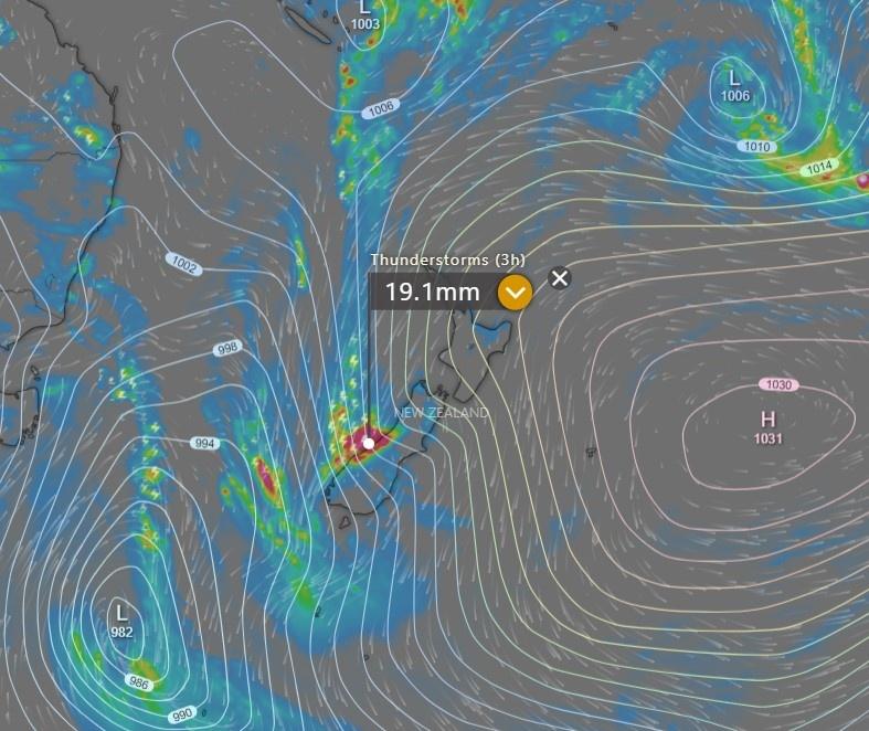
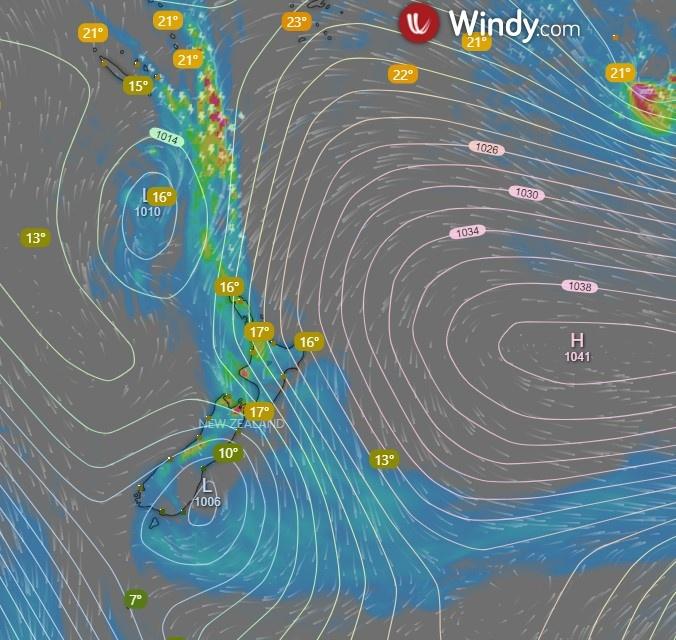
The image below (Courtesy of Windy.com) provides a slightly wider view tonight, illustrating exactly where the moisture is coming from, and how this system is set up:
With the High pressure to the east of the country intensifying, it's essentially staying put - a blocking high for the low pressure coming in from the west. The air from the high pressure is pushed up into the tropics, heated and therefore can carry more moisture. It then hits the colder air associated with the low pressure - in the image above you can see there is a temperature difference of around 27C-18C = 9 degrees C. This causes the moisture to be dropped from the warm air, and it's directed down the back of the high pressure and forced onto the west coast of New Zealand.
Comparing this to last nights image the temperature difference was only about 5C, indicating that the rain-making engine has increased it's ability to generate moisture over the last 24 hours.
During the day, heavy rainfall has occured in the Nelson and Tasman regions. Many roads in Golden Bay are now closed due to slips.
A state of emergency was declared in Nelson Tasman, with over 200 homes requiring evacuation.
The Maitai River, which is usually a fairly sedate river, has broken it's banks.
River flow measurements available on the Tasman District Council’s website showed the river went from flows of 3.31 cubic metres per second (cumecs) at 5am, to 446.87 cumecs at 4pm.The flows increased steadily from 5am to noon, when there were 91.61 cumec flows, before sharply increasing from 1pm onwards.
- Stuff.co.nz
In Takaka (Golden Bay), more than a months rainfall occured within 15 hours.
Roads between Blenheim and Nelson have also been closed until at least Friday.
Further down the island, Buller and the West Coast have reported flooding, but so far not as bad as was expected. About 130 homes have been voluntarily evacuated. Rainfall has been heavy in river catchment areas, and for the Buller area, the Buller River is expected to peak over night tonight. This translates to flooding downstream, as was the case with the Maitai River, described above. Therefore it's likely the impact of this event on Buller will be better known from tomorrow.
Moving the model forward it appears that there will still be significant rainfall to central New Zealand , and the West Coast until at least late on Saturday evening.
Rain continues to fall in Nelson, Golden Bay, and Buller. All three regions are now under red warnings from the Metservice. Heavy rainfall has also fallen today in Northland, and much of the North Island ins now under some sort of rain watch or warning.
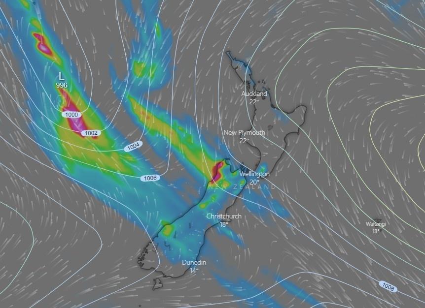
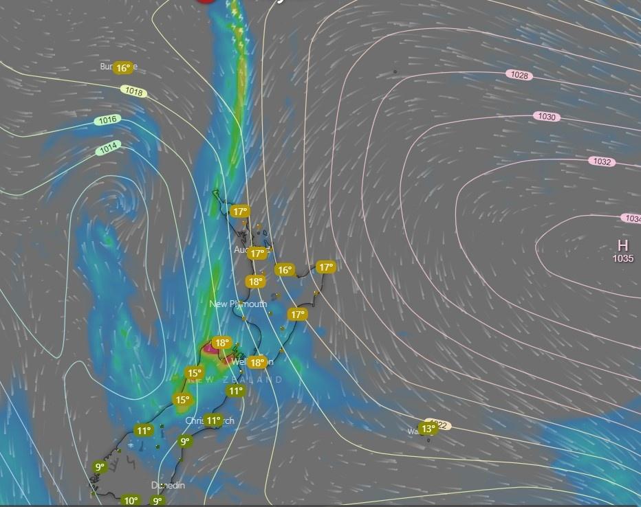
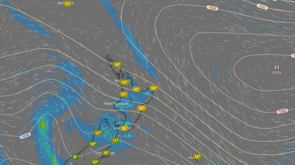
Today's screen grab was taken at 9:00pm tonight:
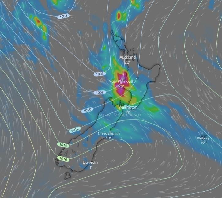
The High pressure, largely stays put. As it's not moving, the Low pressure that was squeezing up behind the high pressure gets pushed south, and turns the tail of the rain band towards Marlborough and Wellington regions. Orange rainfall warnings are in place tonight for these areas.
Northland and Taranaki also get some significant rainfall as the rain band gets pushed further east. Another Low has developed to the North West of New Zealand. The temperature difference between the warm and colder side of the front is now slightly less at 6C. While this still creates stormy conditions (lightning) and heavy rainfall, it suggests that the rainfall generating area of this storm is weakening.
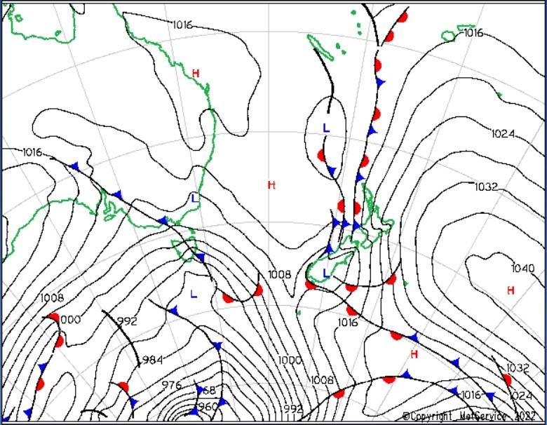
The map below shows the rather complicated setup at 6pm tonight:
The video below was captured at midday today (before the low pressure crossed the South Island). It captures a period of time using the predictive ECMWF model up to early Sunday morning when the main rainband moves off the country
You can see during this period that the high pressure weakens and moves north, allowing the part fo the rainband affecting the North Island, to move to the east of the country. However this takes a number of days, so at this point there is still alot of rain to come down from the tropics.
The anticyclone to the east of the country holds steadfast, although it's now showing signs of a slight weakening, having dropped 6mb of central pressure in the last 24 hours. The ECMWF model suggests a similar pattern over the next 24 hours. Rainfall wise, the slight weakening of the anticyclone and the splitting of the low pressure (central pressure around 1012 mb) has allowed the main rain band to move into a more northerly position.
This means that heavy rainfall is still (at 9pm tonight) occuring in the Nelson Tasman area. The good news is that the rain band will move rapidly across the North Island tonight, and is expected to lie to the east of the country at midday tomorrow. There will be some showers about but nothing as heavy as has been seen in previous days.
A state of emergency has now also been declared in Marlborough today, following Nelson Tasman and Buller regions earlier in the week. Northland also has been hit hard with flooding. Wellington has also seen several additional slips today. Nelsons Mayor has said the damage done to the area this week will take years to recover from.
The video below indicates the ECMWF model prediction over the next 24 hours
Alot has changed since last night. The Anticyclone to the east of the country has again decreased it's intensity, allowing the main rain band to move off the country. There's still some showers about, but by and large it's time to dry out. A seperate system is now across Fiordland and as of midday this is the only area with a red warning in place.
If you think this article was helpful, there are a number of ways you can thank us. Feel free to add a comment and say thanks in the comments section below, or provide feedback if we've got something wrong. Also you are welcome to register on the site for free. The more members we have the more it encourages us to write these types of articles. Alternatively if you are into all that social media stuff, feel free to share the article using the social media buttons at the top of the page, and tell others about the site. Thanks for your support!!
A significant weather event is forecast to occur in Westland and Buller over the next few days. Westport itself was hit by a weather event that cuased significant flooding and damage in July 2021 and many residents are still rebuilding from this storm. This event is expected to be larger.
Setup
As you can see from the image above, moist air is being fed from the tropics and pushed onto the West Coast of the South Island. This is expected to occur for the next two to three days.
Warnings
The MetService has published a Red Warning for this event. Red Warnings are only issues in frequently and where significant impact is expected from weather conditions. At 02 Feb 2022 2030 the following warning had been issued
NOTE THAT THIS IS NOT A CURRENT WARNING. OFFICIAL WARNINGS CAN ONLY BE ISSUED BY THE METSERVICE. FOR THE LATEST WATCHES AND WARNINGS PLEASEREFER TO THIS PAGE
Westport so far seems to have escaped much of the planned rainfall. More rainfall is expected to fall though in this multi day event.
In the past 24 hours
The tropical flow that was coming from the tropical area to the North East of Australia, is now no longer as pronounced as it was yesterday. Much of the moisture associated with this flow is now being merged into a low pressure which is also being fed with cooler air from the south. With the cooler area mixing with the warmer air, rainfall is created and we can see this on the diagram in the top left.
The other tropical flow that was evident on yesterdays image, still exists, and that is driving the rain into the Nelson, Tasman and Buller regions
The high pressure to the right remains where it is, which will push the low pressure back down onto the West Coast on Friday afternoon.
An Incoming high pressure that curently sits below Tasmania will eventually push the rain band up into the lower North Island on Sunday and Monday
A Red Warning: Heavy Rain is still in place for the Ranges in Buller with between 250 to 350mm of rainfall to occur on what has already fallen at the coast.
4th February 2022 8:30pm
The setup tonight remains similar to what it was last night. Cold air flows in from the south, mixing with warm moist air from the north. Temperatures reamin warm on the north side of the system. The temperature in Napier currently (9pm) is 27C! While on the Southern side of the system, temperatures are much colder - between 11C and 14C on the east coast of the south island.
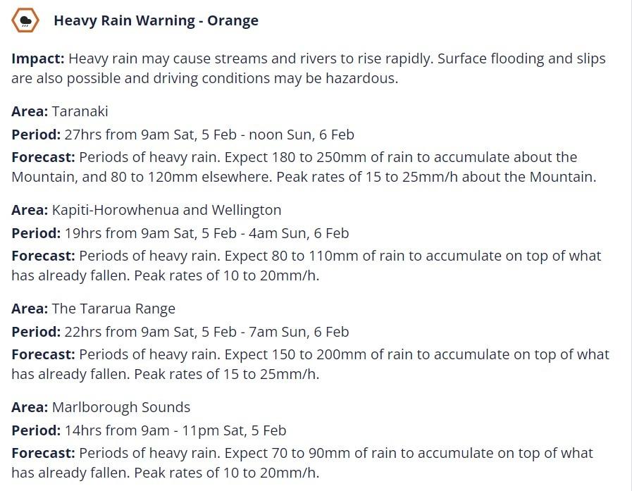
The rain slowly moves north overnight, with an orange warning now in place for Wellington and Marlborough (100 to 120mm over 24 hours, at times with a rate of 10 to 20mm per hour).
There have been several evacuations in and around Westport today (Refer news articles below)
The Image below shows the period from around midnight on 4th Feb to the evening of Monday 7th Feb. The model used is the ECMWF model:
5th February 2022 8:30pm
The storm continues to move slowy north. 93mm of rainfall has been recorded today in Lower Hutt (an additional 8mm yesterday).
There are no Red Heavy rain warnings currently in place. Orange heavy rain warnings still remain in place as follows.
NOTE THAT THIS IS NOT A CURRENT WARNING. OFFICIAL WARNINGS CAN ONLY BE ISSUED BY THE METSERVICE. FOR THE LATEST WATCHES AND WARNINGS PLEASEREFER TO THIS PAGE
Niwa (@niwa_nz ) have published an infographic that allows you to see where the rain fell from this event:
‼️ Three locations in the @niwa_nz station network observed more than 1,000mm of rain over the last few days‼️
That’s more rain than Christchurch gets in a whole year 😲
If you think this article was helpful, there are a number of ways you can thank us. Feel free to add a comment and say thanks in the comments section below, or provide feedback if we've got something wrong. Also you are welcome to register on the site. The more members we have the more it encourages us to write these types of articles. Alternatively if you are into all that social media stuff, feel free to share the article using the buttons below, and tell others about the site. Thanks!!
We're currently watching a Spring storm which is expected to intensify in the Tasman sea, and move rapidly south east over the next day or so. The video below shows the ECWMF forecast from 3am Friday 25th September, though to around 3am Wednesday 30th September.
On the current model the low pressure starts over south Australia and Tasmania, but intensifies significantly as it moves south east. By Sunday midnight it sits SW of Stewart Island with a central pressure of 975mb. Associated with the low there are widespread showers across the country, with significant rainfall on the West Coast of the South Island, from a NW windflow.
During Sunday, the front moves up the country, dragging behind it cold polar air from the SE. Expect this to reach the middle of the country by around 5pm Sunday.
Overnight Sunday and into Monday the low pressure continues to deepen to the SE of the country, this time dragging snow to low levels across much of the South Island. Snow will continue to fall to low levels in Otago and Southland into Tuesday, while strong cold southerlies affect the rest of the country. By midday Monday, the Low pressure has a core pressure of 934mb, and lies about 1200km SE of New Zealand.
There are many warnings out for this system, and as always with a significant weather event like this, keep an eye on those forecasts and warnings on the MetService website
We'll be keeping an eye on this event over the next few days and provide updates to this blog as things progress. Feel free to provide your feedback in the comments section below, and let us know how things are going at your place!
Links:
Newshub - NZ weather: 'Significant wintry blast' to hit Monday after possible offshore 'weather bomb' sends severe, cold gales our way
NZ Herald - Severe weather: Widespread warnings as weekend weather bomb due to hit



 No comments