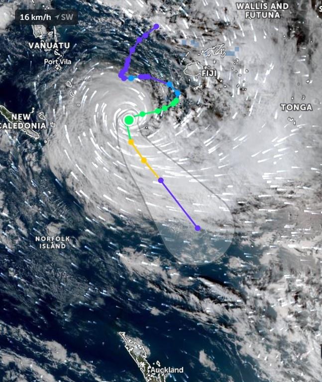
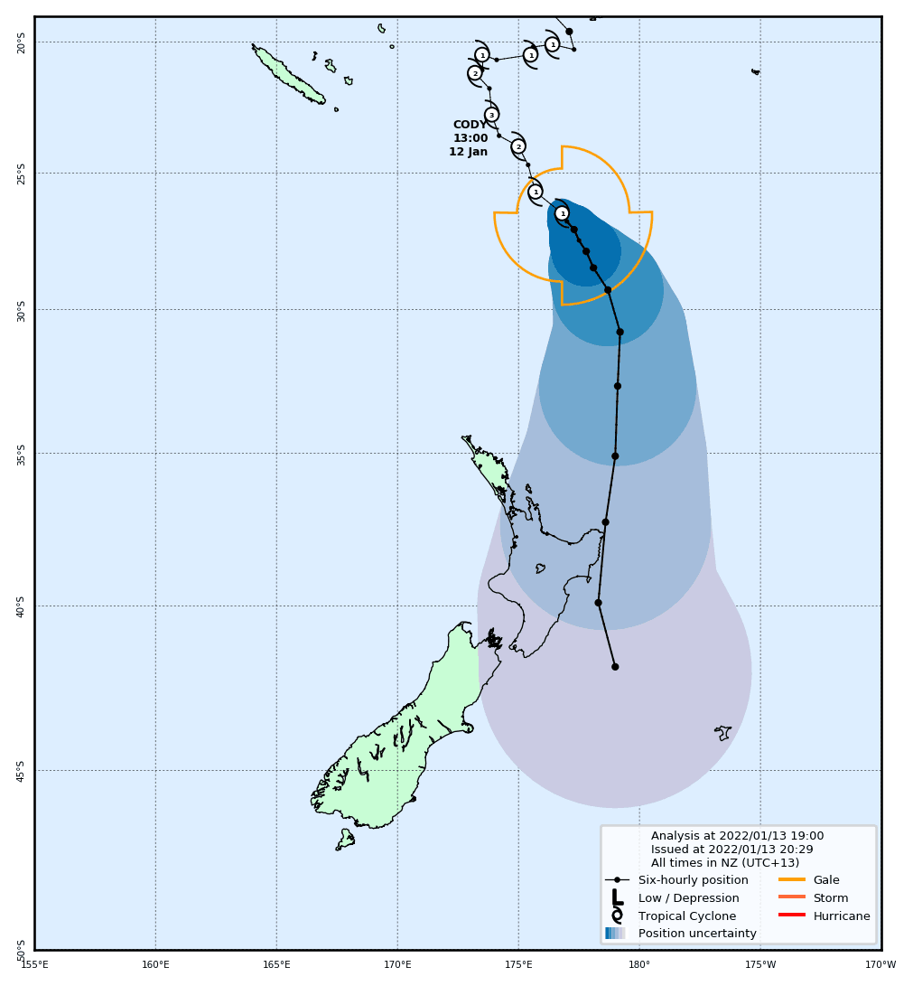
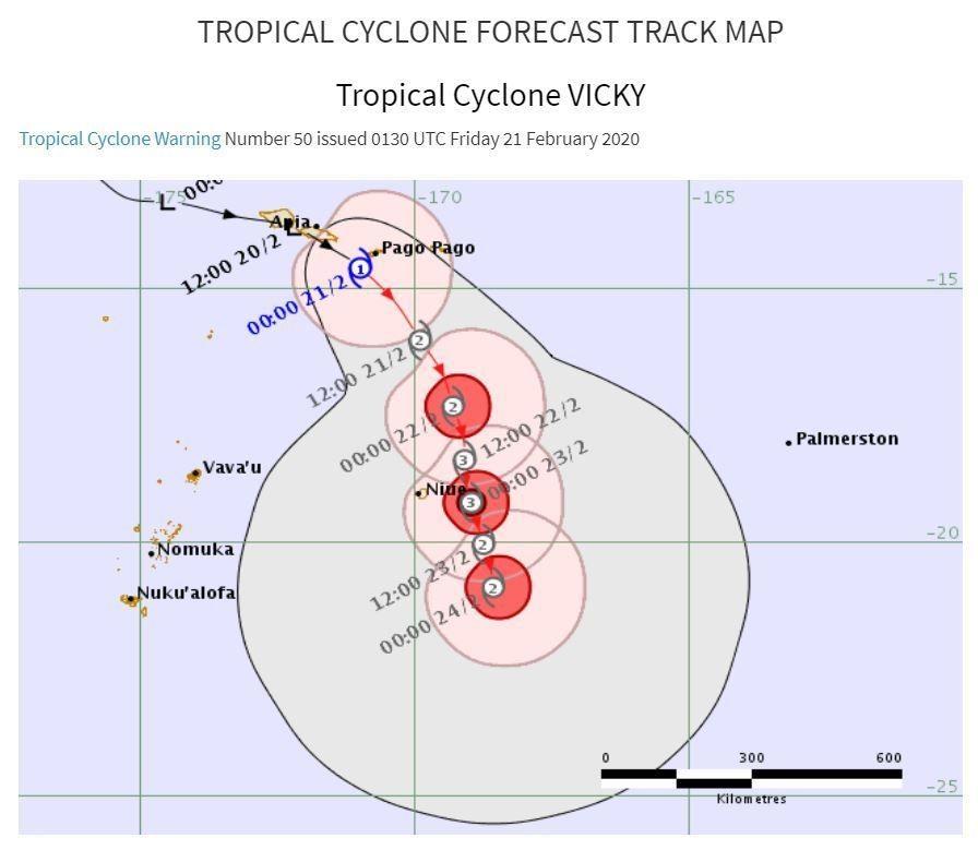
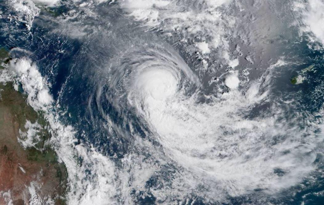
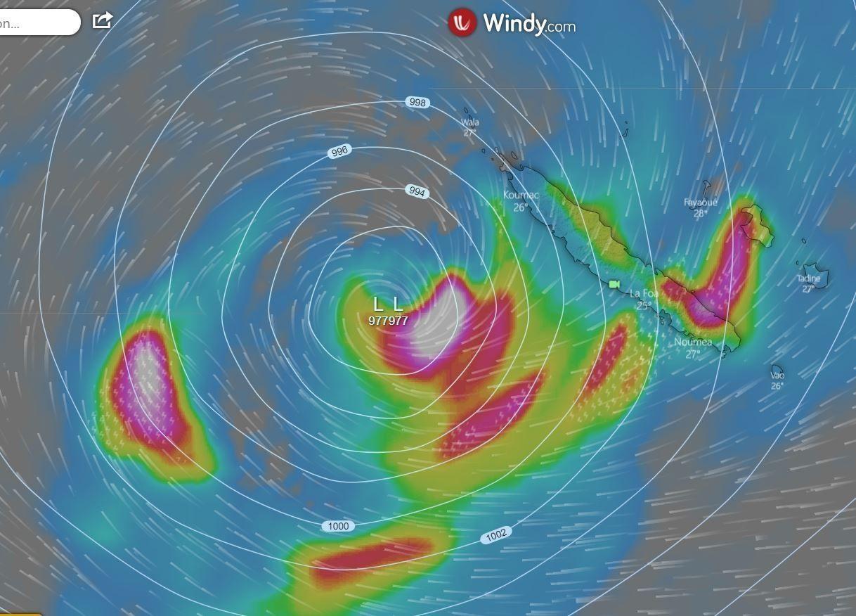
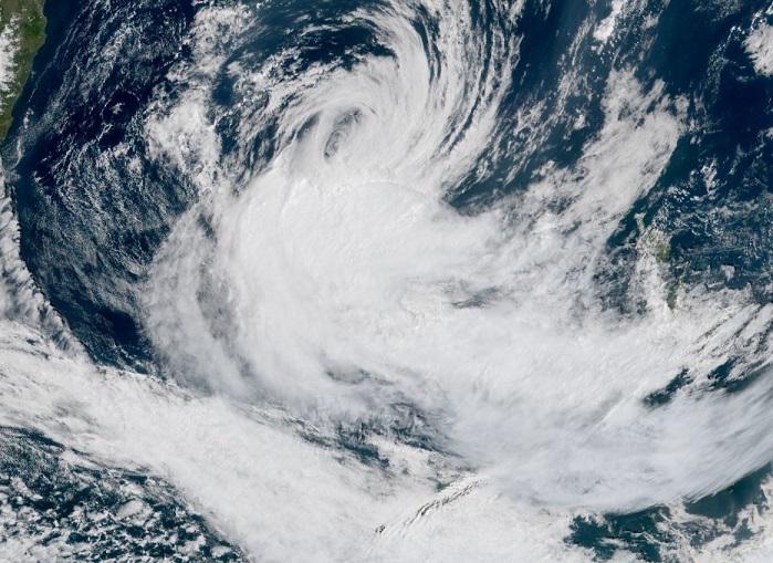
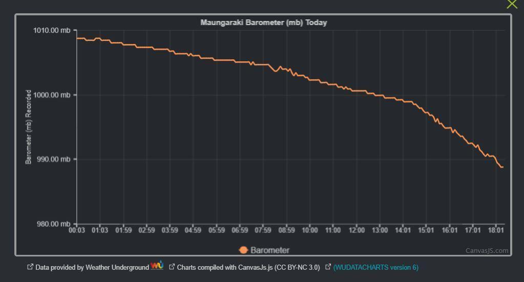
TC Fili formed briefly in the sea around New Caledonia. The image below shows the cyclone track and time line:
Ex TC Fili has moved South East and moved onto the north of New Zealand's North Island today. It's expected path is as follows:
The above shows wind strength From 10pm 12th April 2022 for the following 48 hours. As the centre of the depression heads south east, strong winds are focussed on the East side of the North Island.
For the equivalent period, the video below shows expected rainfall amounts. Red is about 20mm per hour.
The MetService has issued watches and warnings for the entire North Island, as well as surrounding coastal areas:
Expect 200 to 300mm of rain to accumulate. Peak rates of 15 to 25mm/h, but 35 to 50mm/h possible in localised places late Wednesday morning and afternoon. Thunderstorms also possible.
Impact:
This rain is expected to cause dangerous river conditions and significant flooding. Slips and floodwaters are likely to disrupt travel, making some roads impassable and possibly isolating communities.
Expect 210 to 310mm of rain to accumulate. Peak rates of 15 to 25mm/h, but 35 to 50mm/h possible in localised places Wednesday afternoon and evening.
Impact:
This rain is expected to cause dangerous river conditions and significant flooding. Slips and floodwaters are likely to disrupt travel, making some roads impassable and possibly isolating communities.
Ex TC Fili continues to follow a track similar to the one outlined last night. As expected impacts have been felt mainly around the East Cape area of the North Island:
Video Source: Television New Zealand (TVNZ)
Other notes include:
Significant power disruption throughout the day. Some residents are currently without power
SH35 closed due to trees blocking the road
Residents advised to stay at home and avoid unnecessary travel tonight
Widespread flooding:
In the 24 hours to 5pm today, 189mm of rain has fallen at East Cape Lighthouse
A Red Heavy Rain warning is in place to 1am Thursday for Gisborne. Total rainfall from this event is expected to reach 200mm
A Red Heavy Rain Warning is in place to 4am tomorrow for Wairoa and surrounding areas. Total rainfall from this event is expected to reach 180mm
Orange wind warnings are in place for both Gisborne and Hawkes Bay, east of Wairoa.
Overall the system continues to move South East away from the country, and it's expected that more settled weather will move across the North Island from an approaching high pressure to the West, over the next 24 hours.
Cyclone Hola is the third ex TC to reach NZ shores this season. It's a much smaller system, but is likely to have an impact on the Upper North Island, through Coromandel and the Bay of Plenty.
11th March 2018 9:00am
GFS and ECMWF models currently differ in path. The generally more accurate ECMWF forecast is shown below:
The image above shows the forecasted situation at 6am Monday. Strong winds are already impacting Northland, and wind is increasing in Auckland. Central pressure is 991mb. Rainfall is largely confined to the South to SW quarter of the system. Heavy rain is expected to be falling in Northland, particularly towards Cape Reinga. Auckland should receive around 5mm of rain during the period 3am to 6am
The above image is the predicted situation on Monday at 1pm. Ex TC-Hola has made landfall at Cape Reinga and will continue to track down the island until just north of Auckland. At this point, wind will be gusting up to 50 knots in Auckland around 5pm. Central pressure has dropped to 989mb. Rainfall will be widespread across the North Island, though only heavy falls will occur close to the centre of the Low pressure. Auckland should expect heavier rain in the evening, for a period - up to 12 mm in 3 hours.
The above image shows the forecasted situation at 10pm Monday. Ex TC-Hola will have moved eastwards slightly, and is now centralised on Coromandel. From here the expected path is expected to be across the Bay of Plenty.
Winds in Auckland will move to the Southerly quarter and will decrease quickly as the system moves away.
The GFS model predicts a similar track, but further out to sea. If this occurs then the impacts from this storm will be less for the upper North Island, Aucland and Bay of Plenty.
11th March 2018 1630
The real colour Himiwari-8 satellite image is as follows. The centre of the system is at top left
12th March 0800
ECMWF model has changed over Sunday, and ex TC-Hola is now expected to track further to the west. This will mean that impacts from this system will be significantly less for those in the north of the North Island. There will still be some rain and strong winds North of about Taupo.
12th March 2018 1900
Not too much to report on this one. The main impact of the system has gone out to see and now misses any areas of land. There have been some impacts of note though
Kerikeri - 30mm of rain 12 midnight to noon today
Great Barrier Island - highest sustained winds 45km/h
Cyclone Tino was the first tropical cyclone for 2020 (and for the 2019/2020 tropical cyclone season) for the South West Pacific.
Monday 13th January 2020
The Fiji Meteorological service issued a Media Release saying a tropical disturbance was likely to form into a tropical cyclone later in the week. The tropical disturbance was approximately 1670 kilometers to the far northwest of Fiji.
A heavy rain alert was issued at 9am by the Fiji Meteorological Service.
At 3pm, tropical disturbance TD04F was analysed approximately 1180 kilometres westnorthwest of Nadi or 410 kilometres north-northwest of Port Vila, the capital of Vanuatu. TD04F is slow moving and is anticipated to make a southeast movement. The potential for this system to develop into a tropical cyclone is moderate to high in the next 24 hours and high in the next 48 hours.
At midday, tropical disturbance TD04F was located near 13.1 south latitude, 170.4 east longitude or about 725km west of Rotuma. Close to its centre TD04F is expected to have average winds of up to 40km/hr with momentary gusts to 60km/hr.
TD04F is expected to gradually intensify into a tropical depression by this evening and expected to further intensify into a category 1 cyclone by tomorrow evening.
TD04F is cuirrently moving eastwards at about 19km/hrs. On this track the centre is expected to be located about 580km west of Rotuma at 12am tomorrow and about 374km west of Rotuma at 12pm tomorrow.
Most forecasting models are indicating tropical disturbance TD04F will track towards Vanua Levu as a category 1 tropical cyclone on Friday and could possibly intensify further to a category 2 system.
Therefore, heavy rain with squally thunderstorms and strong winds is anticipated especially over Vanua Levu from later today becoming gale force winds from later tomorrow.
At midday today, tropical depression TD04F was located near 11.7 south latitude, 173.4 east longitude or about 410km west-northwest of Rotuma and about 800km north-northwest of Nadi. Close to its centre TD04F is expected to have average winds of up to 45km/hr with momentary gusts to 80km/hr. TD04F is moving east at about 10km/hr and is expected to gradually intensify into a category 1 cyclone by later today. TD04F is expected to gradually turn towards the southeast and move at about 20km/hr in the next 24hrs. On this forecast track, the centre is expected to be located about 170km north-northwest of Labasa at 12pm tomorrow and 200km southeast of Labasa or about 75km northwest of Lakeba at 12am on Saturday.
Tropical Depression TD04F intensified to a category one tropical cyclone at 3am today and named Tropical Cyclone(TC) Tino. TC Tino is anticipated to make landfall over Vanua Levu at 6pm today. At 11am today, TC Tino was located near 14.2 south latitude, 177.9 east longitude or about 210km south-southeast of Rotuma and about 300km northwest of Labasa at 9am today. Close to its centre the cyclone is expected to have average winds of up to 75km/hr with momentary gusts to 100km/hr. TC Tino is moving south-southeast at about 20km/hr. On this forecast track TC Tino is expected to be located about 70km east-southeast of Labasa or 130km west-northwest of Vanua Balavu at 9pm today and about 40km south of Lakeba or 170km north-northeast of Ono-i-Lau at 9am tomorrow.
Radio New Zealand reports that Tuvalu "inundated by waves whipped up by Tino". Tino passes around 500km from Tuvalu, but still resulted in waves of up to 8m, in open water
RNZ also reports that evacuation shelters are being opened in Tonga, in preparation for TC Tino's arrival.
10am (image source - Windy.com) - TC Tino now rated as Category 2
Tino has a central pressure of 968mb, and is steadily weakening as the TC moves south and into cooler waters.
Radio New Zealand reports that overnight, Tonga's main island has been spared the full force of Tino.
Cyclone forecast track:
Monday 20th January 9:00am
Cyclone Tino has been reclassified as an extra tropical low. It is now well away from any land mass, however is still expected to impact the east cost of New Zealand's North Island with waves of between 2-3m. Predicted tack follows:
Both GFS and ECMWF have this storm dropping to the south. On Friday 24th at 6pm NZDT the storm is expected to have a central pressure of somewhere between 93o and 923mb (depending on which model you choose). It will still pack a punch with winds around 40 knots. Here's the windy.com plot for the ECMWF , for that time period.
Originally a Tropical Depression, formed over the Gulf of Carpentaria in late January, Lucas has tracked eastward to reach TC status around 1pm on Jan 31st. It's currently a Category 1 cyclone, having initially weakened from a Cat2.
Lucas is tracking along the southern edge of a ridge and through a favorable environment with very warm (29-30°C) sea surface temperatures, low (10-15 knots) vertical wind shear and moderate poleward outflow aloft.
The current favorable conditions will be tempered by diminishing upper level support and moderate shear, but Lucas is still expected to gradually intensify in the near term, resulting in 110 km/h (60 knots) in 24 hours.
Subsequent to that Lucas is expected to turn towards the South, where it will see increasing shear, and colder waters. As a result the TC is expected to weaken as it passes either over or around New Caledonia, sometime around February 3rd.
Tropical Cyclone Lucas 2021 Last Modified: 09:00 February 2, 2021 UTC
Cyclone Lucas 2021Lucas 2021 Lucas is located 244 km (132 nautical miles) west-southwest of Port Vila, Vanuatu, and has tracked southeastward at 31 km/h (17 knots) over the past 6 hours.
Satellite imagery shows deep, central convection that has begun to warm significantly over the past 6 hours. The initial position is placed with fair confidence based on the convective features in a timely SSMIS image that further reveals the deep convection associated with the system is sheared 74 km (40 nautical miles) to the south-southeast of the current position.
Lucas is tracking along the southwestern periphery of a near-equatorial ridge and through a marginal environment with warm (27-28°C) sea surface temperatures and robust poleward outflow aloft offset by high (30+ knots) vertical wind shear and convergent upper level flow along the northeastern periphery of the system.
In the near term, Lucas will maintain a 85 km/h (45 knots) intensity in 12 hours and then begin a gradual weakening trend due to continued high wind shear.
A building subtropical ridge positioned to the southeast will take over steering from the near-equatorial ridge after 24 hours and begin to drive the system on a generally southwestward track after 36 hours.
Continued high wind shear and cooling sea surface temperatures thereafter will lead to further weakening and ultimately lead to dissipation over water in 3 days.
Forecast models are in overall fair agreement with a maximum spread in model solutions of 250 nautical miles in 2 days that increases slightly thereafter for the remainder of the forecast period.
This relatively large spread in numerical model solutions lends overall fair confidence in the JTWC forecast track which is placed on the multi-model consensus.
Maximum significant wave height is 4.9 meters (16 feet).
Information provided by the Joint Typhoon Warning Center (JTWC).
03 February 2200hrs
After weaving it's way across the Coral Sea, TC Lucas has moved south and is currently sitting near New Caledonia, having just crossed the Pacific island.
From the Zoom Earth website
Lucas is located 106 km (57 nautical miles) east-northeast of Noumea, New Caledonia, and has tracked southward at 24 km/h (13 knots) over the past 6 hours.
Satellite imagery shows the central convection remains sheared southward partly exposing the low level circulation (LLC). The satellite imagery loop also shows vigorous cold air advection as evidenced by stratocumulus cloud lines wrapping into the LLC.
Cyclone phase analysis indicates Lucas is quickly becoming subtropical and will complete subtropical transition in 12 hours.
Supporting us and feedback
If you think this article was helpful, there are a number of ways you can thank us. Feel free to add a comment and say thanks in the comments section below, or provide feedback if we've got something wrong. Also you are welcome to register on the site. The more members we have the more it encourages us to write these types of articles. Alternatively if you are into all that social media stuff, feel free to share the article using the buttons below, and tell others about the site. Thanks!!
TC Bina formed as a tropical low in the NE Coral Sea. It's then followed a NE route, turning SW towards Fiji. It very briefly reached Tropical Cyclone status between 1pm Jan 30 for roughly 18 hours. Max wind speed was estimated to be around 85 km/h. It's now classed as a tropical depression as it crosses Vanu Levu, Fiji. It's expected to continue to lose strength as it continues to move South East.
It's a busy area of the Pacific at present with TC Ana (SSW Fiji) accompanied by TC Bina (Fiji) and TC Lucas (Coral Sea):
TC Ana was officially named North West of Fiji on 30th Jan, as a cat 1 TC. It has subsequently crossed the island of Viti Levu as a Cat 2 storm and then increased to Cat3 as it continued South East over Kadavu.
Fiji Meteorological Service issued the following tropical Disturbance Summary at 0330UTC today.
TROPICAL DISTURBANCE ADVISORY NUMBER A17 ISSUED FROM RSMC NADI Feb 010330 UTC. TROPICAL CYCLONE ANA CENTRE 975HPA CATEGORY 2 WAS LOCATED NEAR 21.2 SOUTH 179.0 EAST AT 010000 UTC. POSITION FAIR. REPEAT POSITION 21.2S 179.0E at 010000 UTC. CYCLONE MOVING SOUTH AT 07 KNOTS. CYCLONE WEAKENING. EXPECT SUSTAINED WINDS OF 60 KNOTS CLOSE TO THE CENTRE DECREASING TO 50 KNOTS BY 011200 UTC. EXPECT WINDS OVER 47 KNOTS WITHIN 50 NAUTICAL MILES IN NE QUADRANT AND WITHIN 50 NAUTICAL MILES IN SE QUADRANT AND WITHIN 30 NAUTICAL MILES IN SW QUADRANT AND WITHIN 30 NAUTICAL MILES IN NW QUADRANT EXPECT WINDS OVER 33 KNOTS WITHIN 150 NAUTICAL MILES IN NE QUADRANT AND WITHIN 150 NAUTICAL MILES IN SE QUADRANT AND WITHIN 80 NAUTICAL MILES IN SW QUADRANT AND WITHIN 60 NAUTICAL MILES IN NW QUADRANT DEEP CONVECTION REMAINS PERSISTENT TO THE SOUTHEAST OF PARTLY EXPOSED LLCC AS TC ANA IS MOVING INTO AREA OF HIGH SHEAR. TC ANA INITIAL WEAKENING AND IS EXPECTED TO BE STEERED TO THE SOUTHEAST BY THE SOUTHEASTERN PERIPHERY OF THE NEAR EQUATORIAL RIDGE LOCATED TO THE EAST OF THE SYSTEM. DVORAK ANALYSIS BASED ON SHEARED PATTERN LESS TAHN 33NM FROM DEEP CONVECTION YIELDING DT=3.5, MET=3.5 AND PT=4.0. FT BASED ON DT. THUS DVORAK T3.5/4.0/D0.5/24HRS. FORECASTS : AT 12 HRS VALID AT 011200 UTC 22.7S 179.8W MOV SE AT 09 KT WITH 50 KT CLOSE TO CENTRE AT 24 HRS VALID AT 020000 UTC 24.5S 178.0W MOV SE AT 11 KT WITH 40 KT CLOSE TO CENTRE OUTLOOK : AT 36 HRS VALID AT 021200 UTC 26.7S 175.7W MOV SE AT 12 KT WITH 30 KT CLOSE TO CENTRE AT 48 HRS VALID AT 030000 UTC 29.1S 173.3W MOV SE AT 13 KT WITH 30 KT CLOSE TO CENTRE THE NEXT TROPICAL DISTURBANCE ADVISORY ON TROPICAL CYCLONE ANA WILL BE ISSUED AROUND 010800 UTC.
Ana is under the influence of a westerly wind shear, and this will slowly increase over the next few days. This combined with the cooler waters, should see this TC dissipate over the next few days. Although there have been no recent microwave satellite passes, (meaning confidence on position is low) tracking models suggest at this point that the TC is unlikely to impact New Zealand.
It's a busy area of the Pacific at present with TC Ana SSW Fiji) accompanied by TC Bina (Fiji) and TC Lucas (Coral Sea)
3rd February
TC Ana has now ventured out to sea SW of Fiji, and is now and ex tropical cyclone
We're well into the TC cyclone season for 2022-23, and with that comes the formation of TC Gabrielle. Officially named by the BoM today, the TC has formed over the Coral Sea to the west of Northern Queensland.
Gabrielle isn't that pretty right now, but it is already looking to be a large TC. ZoomEarth image as at 2000 today:
We're watching this one closely. The main models all agree that the path of the cyclone will across Northland, Auckland, and Bay of Plenty, late Sunday and into Monday. All these areas have seen significant rainfall in the last 2 weeks, and are still in the process of mopping up.
Australia's BoM have provided a good description of what is going to happen over the next few days:
The forecast track is based on a weak mid-level ridge to the east of the
Gabrielle and is forecast to steer Gabrielle to the south through Wednesday. An
upper trough is amplifying over the Australian continent and is forecast to
become the dominant steering influence and takes Gabrielle southeast from
Thursday. An ensemble of numerical weather prediction models give good
confidence in the forecast track, with Gabrielle expected to remain well to the
east of the Queensland coast. The long term track takes Gabrielle close to
Norfolk Island over the weekend. This track produces a dynamic fetch of gale
force northerly winds expected to produce large northerly swells for southern
Queensland.

The environment is favourable for further development tonight and into Thursday
as low-level and mid-level moisture remains high. CIMSS upper level winds
currently analyse Gabrielle in an area of strong upper divergence with outflow
channels to the south and north, and 15 to 20 knots of deep layer shear.

Through to late Friday, the moisture availability will remain high, as
Gabrielle will along track SSTs of 28 to 30 degrees Celsius. Upper outflow to
the south will be enhanced as the upper trough approaches to the south.
Gabrielle is forecast to intensify to Category 2 overnight and to continue to
intensify into a severe tropical cyclone on Thursday. SHIPS RI guidance
suggests a moderate chance of rapid intensification, with the environment
improving. The upper trough will provide increasing vertical wind shear from
Friday, with Gabrielle forecast to gradually transition into a vigorous
sub-tropical cyclone over the weekend as it moves near Norfolk Island.
Gabrielle may weaken a little as this occurs, but is likely to remain at
category 2 intensity with storm force winds and a very large area of gale force
winds even as it loses its tropical characteristics. Gabrielle is likely to
remain a strong low pressure system into next week well outside of the
Australian region.

Copyright Commonwealth of Australia
Windy.com give a better view of what is likely to happen over the next week. This is the most recent ECMWF model, but that said, all the main models show a similar track path, meaning the confidence in the track is high.
Further updates tomorrow night!
09 February 2023 09:30pm
Not too much further to report tonight. TC Gabrielle is currently a CAT2 TC, and expected to increase toa CAT3 intensity tomorrow (2am Friday to 2am Saturday NZDT). As it continues to move southwest over slightly cooler waters it is then expected to decrease in intensity. However the associated wind and rain is now set up and it's this that is expected to hit the northern part of New Zealand on Sunday and into Monday.
Gales have previously been in the eastern sector, 22:40 UTC ASCAT pass
confirming the significant extent in northeast quadrant and extending further
into the southwestern quadrant. Model guidance is consistent with peak winds
being in the northeast quadrant.

The forecast track is based on a weak mid-level ridge to the east of the
cyclone steering Gabrielle currently to the south before an upper trough over
the Australian continent soon becomes the dominant steering influence, to steer
Gabrielle to the southeast. Model guidance is highly consistent providing
confidence in the forecast track, with Gabrielle expected to remain well to the
east of the Queensland coast. The long term track takes Gabrielle close to
Norfolk Island over the weekend. This track produces a dynamic fetch of gale
force northerly winds which is expected to produce large northerly swells for
southern Queensland.

The environment is conducive for further development over the next 24 to 30
hours. CIMSS upper level winds currently analyse Gabrielle in an area of low
wind shear with strong upper level outflow especially to the south. Gabrielle
will remain over warm SSTs until Friday (10 Feb) when they reduce below 28C,
then falling below 26C on Saturday (11 Feb). Gabrielle is forecast to gradually
intensify, peaking at category 3 intensity on Friday.

During Friday the upper trough will provide increasing vertical wind shear and
Gabrielle is forecast to gradually transition into a vigorous sub-tropical
cyclone over the weekend as it moves near Norfolk Island. Gabrielle may weaken
a little as this occurs, but is likely to remain at category 2 intensity with
storm force winds and a very large area of gale force winds even as it loses
its tropical characteristics. Gabrielle is likely to remain a strong low
pressure system into next week well outside of the Australian region.

Copyright Commonwealth of Australia
Tonight's image from Windy.com shows the ECMWF predicted track up to 7am, Tuesday14th February.
This is one of the main models however this still some variation in some of the other models. It's probably safe to say at this point that there will be a direct impact on Northland and Auckland, but exactly what that will look like is still unknown at this point. With this in mind, Metservice have today issued watches for these areas already for next week, and these are expected to be upgraded to warnings at some point. Additionally, the state of emergency in place in Auckland since the last weather event, has been extended into a third week, in main because of the cleanup work that still continues, and the predicted inpact from what will then be Cyclone Gabrielle. More information tomorrow.
11th February 2022 09:00pm
Update at 7pm tonight from Australia's BoM:
Tropical Cyclone Gabrielle is likely maintaining intensity as it gradually
evolves into a subtropical cyclone and continues moving rapidly southeast
towards Norfolk Island.

Position based primarily on animated Vis imagery from Himarawi-9. Dvorak
analysis is becoming less meaningful as shear over the system increases and
deep convection reduces and becomes more removed from the centre. system could
not be assigned a DT from Dvorak analysis with no deep convection within 80 nm
of the centre. MET with a W+ trend is 3.0. FT set at 3.0 and CI remains at 3.5
with weakening constraints.

The system has likely maintained intensity through much of today as it
gradually evolves into a subtropical cyclone. An AMSR2 pass at 11/0234UTC
depicted an expanding wind field with a large area of storm force winds in most
quadrants, but with a wedge of weaker winds on the northern flank of a frontal
boundary extending ESE from the centre, which happens to be over Norfolk Island
at present -- maximum wind gust from Norfolk Island Airport has been 102 km/h
(55 knots). This pass also a small patch of hurricane strength winds to the
southwest of the system, but coincident with the remaining deeper convection.
Objective aids have generally fallen below 40 knots, but are becoming less
applicable as the system becomes more subtropical in nature. Intensity
maintained at 60 knots based on AMSR2 pass.

Gabrielle is undergoing a gradual transition through hybrid/subtropical phases,
with some clear asymmetries present. This is supported by CIMSS Automated Phase
Classification analysing the system as "borderline trop/subtrop". The synoptic
environment is unfavourable to sustain a true tropical cyclone as wind shear
persists over 40kn and the system is now over SSTs below 26C, and moving into
even cooler SST. Nevertheless, the strong low level circulation, supported by
strong upper level outflow and baroclinic processes provided by the upper
trough to the west is likely to sustain a strong system for the next 6 to 9
hours, before it becomes more vertically stacked as the upper trough moves over
the low level circulation and it begins a weakening trend. Most model guidance
suggests there is a reasonable chance this weakening will occur rapidly enough
to prevent storm force winds moving over Norfolk Island.

Gabrielle is being steered by upper level northwesterlies, ahead of a trough
located over the Tasman Sea. There is high confidence in the forecast track
with strong agreement between model guidance (deterministic or ensemble)
resulting in a very narrow cone of confidence associated with the track of
Gabrielle.

Gabrielle will pass very close to or over Norfolk Island in the next few hours.
Gabrielle will continue to transition to a sub-tropical low but remain a robust
circulation into next week as it moves closer to New Zealand.

Copyright Commonwealth of Australia
Northern parts of New Zealand, including Auckland will now be experiencing some rainfall from the outer bands of Gabrielle. This is expected to increase over the next 24 hours. New Zealand's Meteorological Service have issued Red and Orange warnings and watches for much of the North Island. For the latest current watches and warnings you should always refer to the Metservice website
Councils and Emergency Management services have been advising people to prepare for the upcoming weather system. Essentially people are being told to prepare to look after themselves for up to 3 days. Corommandel and Thames have already been told to prepare for evauation. Air New Zealand have already cancelled flights and is investigating moving planes out of Auckland to avoid damage.
TC Gabrielle is now an exTC> As it moved across Nortfolk Island it formally transitioned to Cyclone Gabrielle:
As you can see, associated cloudbands cover all of the North Island and the top part of the South Island. In Wellington today we have seen alot of cloud, but no rain as such. The main rain bands are still tucked in towards the front centre of the cyclone as the following shows:
The above diagram also shows the current predicted path for ECMWF model. Both the UK Metservice and the Austalian Bom have models describing a slightly more easterly path, and the inconsistency between the three models means that where the actual impacts of Cyclone Gabrielle will be is still unclear.
MetService have issued red heavy wind and rain warnings for Northland and Auckland with 200mm of rain and wind speeds of up to 130km/h expected.
Other news:
All Rail services north of Marton cancelled tomorrow. this includes all commuter trains in the Auckland Region.
Auckland Harbour Bridge closed at 3:30pm this afternoon. Aucklanders advised to stay at home tomorrow
Northland have declartred a State of Emergency
MetServce forecasters say this a significant weather event, the type of which hasn't been seen in many years.
Power out to 15 000 Auckland residents. More outages are expected.
Tonight and tomorrow will be key periods for Northland and Auckland, while the next few days will be critical for Coromandel, East Coast and further south.
In the mean time please keep up to date with the latest forecasts and warnings at Metservice.com, and heed the advice below.
An Official Government update about Cyclone Gabrielle has been issued Sunday morning by NEMA, the government's lead agency for emergency management.
Shortly before 11am Sunday, NEMA circulated the following message:
Official Government update – Cyclone Gabrielle
Cyclone Gabrielle will impact much of the North Island with severe gales, heavy rain and very large waves forecast from today through to Tuesday.
This is expected to be an unprecedented and dangerous weather event.
MetService has issued severe weather warnings for many parts of the North Island.
Keep up to date with MetService weather warnings and advice from your local Civil Defence Emergency Management Group.
Adhere to all advice and instructions from authorities.
Cyclone Gabrielle will also exacerbate the impacts for those communities recovering from recent floods
Avoid travelling during severe weather, and check Waka Kotahi for road closures.
Do what you can to prepare your household for the coming days.
Information about preparing for storms can be found at getready.govt.nz.
Call 111 if you feel in any danger.
Stay safe. Don't take any chances.
13th Feb 2023 10:00pm
Cyclone Gabrielle continues to move South East, and is currently centred around the Hauraki Gulf
The image below shows an infra red satellite view, with a wind speed layer on top. In terms of coluring, think of grey colours as sea level temperature. The brighter the white the higher the cloud. Some of the cloud mass has been artificially coloured, in this case in a range from blue to green, to light green to red. In that order, the higher / colder the cloud and the more chance of heavier rainfall. The video shows a 2 hour period.
The first thing to notice is the size of the cyclone. There is significant rainfall now across northern and central North Island, and this moves slowly down the island. This is expected to push down to Wellington, Nelson, Marlborough and Kaikoura tomorrow and the next day.
The next video shows rain impacts, from 12am this morning out to Friday, based on ECMWF model. You can see in this video that heavy rain is going to impact a number of areas in the North Island, which is the reason for the number of wind and rain warnings issued by the met service.
Finally, forecasted wind impacts are as follows:
You can see that strong winds (in the red) will impact the West Coast of the North Island for a period, as the cyclone rotates down and to the East. Wellington will see strong winds all the way through to Friday
Cyclone Gabrielle today has caused significant issues in Northland, Auckland and Coromandel. However from the analysis above you can easily see things aren't over yet. Gabrielle is a big system!
14th Feb 2023 9:30pm
Not too much to add meteorological wise tonight. The predicted cyclones path and impacts incl rain and wind are similar to last night. The centre of the cyclone has a pressure of around 975mb, which is extremely low. The centre lies to the east of Ruatoria, and will continue to move South East over the next few days.
There have been significant impacts as the system has moved down the North Island. Auckland has had an opportunity to view the damage, while Napier, Hastings and the East Coast, have been hit hard. Power and Internet has been cut to much of this area, as has mobile coverage, and communication with people around Wairoa remains difficult, via satellite phone. Wairoa is cut off from both the North and the South and it is know that the river has burst it's banks.
A state of national emergency was declared today, meaning that management of resources and support is provided at government level, as opposed to regional level, and covers areas closest to the cyclones path. This is only the third time this has been called in NZ's history. Many have not seen such similar impacts since Cyclone Bola, and Cyclone Gabrielle is being termed a "once in a generation" storm.
225,000 people are without power. In some cases it will be 2 to 3 weeks before power can be restored. It's estimated 2500 people have been displaced.
For further details on impacts today we have provided a number of media clippings for reference. Further updates tomorrow.
15th February 7:00pm
Cyclone Gabrielle continues to move away from the country. There remains a bit of a flick in the tail, in the Lower North Island tonight and tomorrow, with Orange rain warnings in place for the eastern hills of Wellington across to Wairarapa. The same area to the west is under a rainfall watch for a similar period of time. Christchurch, Canterbury and Kaikoura also seem to be getting some rain at the moment.
The cyclone has a central pressure of around 984mb, so a 10mb increase in the last 24 hours. It's still a deep low, but as you can see, it's not as deep as it was!
The video above shows the wider view of what's going on. Gabrielle has muscled it's way in before a blocking high on the right hand side. As the high pressure to the east is not moving, the only way the system has to go is round the bottom. So the blocking high is responsible for the cyclone slowing down as it moved across the upper and central North Island. This has meant that the cyclone has stayed around longer than it normally would without the blocking high, and therefore it's impacts have been more severe.
There is a good descripton here of the processes at work:
Tropical Cyclone Judy was officially named today, by the Fiji Meteorological Service, whose domain it currently falls under. Currently North East of Vanuatu, the TC is expected to track down theisland nation over the next 48 hours.
The TC currently is pulling heat and moisture from tropical areas, allowing it to become stronger. As the cyclone moves south, this becomes less prominent
TC Judy 9pm 27th Feb Wind / Pressure
TC Judy 9pm 27th Feb Wind/Rainfall
Track map for Judy is as follows:
Met.govt.fj have issued a Tropical Cyclone Advisory:
TROPICAL DISTURBANCE ADVISORY NUMBER A4 ISSUED FROM RSMC NADI Feb 270803 UTC. TTROPICAL CYCLONE JUDY[JU-DEE] CENTRE 994HPA WAS LOCATED NEAR 12.5S 169.6E AT 270600 UTC. POSITION POOR BASED ON HR HIMAWARI EIR IMAGERY AND PERIPHERAL SURFACE REPORTS. CYCLONE MOVING WEST-SOUTHWEST AT ABOUT 8 KNOTS. MAXIMUM 10-MINUTE AVERAGE WINDS NEAR THE CENTRE ESTIMATED AT ABOUT 40 KNOTS. ORGANISATION CONTINUES TO IMPROVE. DEEP CONVECTION LIES TO THE WEST AND NORTH OF THE SUPPOSED LLCC. SYSTEM LIES JUST TO THE NORTH OF AN UPPER RIDGE IN A MODERATE SHEARED ENVIRONMENT WITH GOOD OUT FLOW. CYCLONIC CIRCULATIONS EXTEND UPTO 300HPA. SST IS AROUND 30 DEGREES CELSIUS. CYCLONE IS BEING STEERED WEST-SOUTHTHWEST BY THE SUBTROPICAL RIDGE LOCATED TO THE SOUTHEAST OF THE SYSTEM. DVORAK ANALYSIS BASED ON 0.5 WRAP ON LOG 10 SPIRAL YIELDS DT=2.5, PT=3.0 AND MET=3.0. FT BASED ON MET THUS YIELDING T2.5/3.0/D1.0/24HRS.
At this stage there is no indication that this TC will significantly impact New Zealand, however models don't yet agree out to Friday when the system will be near the country, so there is still some uncertainty.
More tomorrow night!
28th February 2023 10:00 pm
TC Judy now sits on and around the northern islands of Vanuatu. It has grown in strength in the last 24 hours and is now classed as a Category 2 cyclone
Met.govt.fj have issued an updated Tropical Cyclone Advisory:
TROPICAL DISTURBANCE ADVISORY NUMBER A8 ISSUED FROM RSMC NADI Feb 280737 UTC. TTROPICAL CYCLONE JUDY[JU-DEE] CENTRE 975HPA WAS LOCATED NEAR 14.5S 168.3E AT 280600 UTC. POSITION FAIR BASED ON HR HIMAWARI EIR IMAGERY AND PERIPHERAL SURFACE REPORTS. CYCLONE MOVING SOUTH-SOUTHWEST AT ABOUT 09 KNOTS. MAXIMUM 10-MINUTE AVERAGE WINDS NEAR THE CENTRE ESTIMATED AT ABOUT 60 KNOTS. ORGANISATION GOOD WITH LLCC LOCATED UNDER DEEP CONVECTION. SYSTEM LIES JUST TO THE NORTH OF AN UPPER RIDGE IN A LOW SHEARED ENVIRONMENT WITH GOOD OUT FLOW TO THE NORTH AND SOUTH. CYCLONIC CIRCULATIONS EXTEND UPTO 300HPA. SST IS AROUND 30 DEGREES CELSIUS. CYCLONE IS BEING STEERED SOUTH-SOUTHWEST ALONG THE PERIPHERARY OF THE SUBTROPICAL RIDGE LOCATED TO THE SOUTHEAST OF THE SYSTEM. DVORAK ANALYSIS BASED ON EMBEDDED CENTRE IN MG YILEDS DT=4.0, PT & MET AGREE. FT BASED ON DT THUS YIELDING T4.0/4.0/D1.0/24HRS.
Global models are beginning to agree on a path over the next few days. Hopefully they will stay in agreement, and this will give us a good indication on whether this TC will impact New Zealand or not.
02 March 2023 9:00 pm
Things just got complicated!. TC Judy has continued to move south on it's planned track, however another low has formed in it's wake, and out of that has formed TC Kelvin
Judy continues on it's planned path , but is losing some energy as it moves further South East over cooler waters. Both TC Kevin and TC Judy are expected to follow similar paths as they are subject to the same forces.
Further details from zoom.earth
Judy is located 648 km east of Noumea, New Caledonia, and has moved southeastward at 26 km/h (14 knots) over the past 6 hours.
Judy is forecast to continue on its southeastward track as it progresses along the outer edge of the subtropical ridge to the east-northeast.
As Judy transits poleward, it will be in an increasingly hostile environment characterized by stronger wind shear, and increasing dry air entrainment, these factors will conspire to weaken the system to around 130 km/h (70 knots) in 24 hours.
After 24 hours, the system will begin its subtropical transition (STT) and a further decrease in intensity to 100 km/h (55 knots) is anticipated as the system crosses the 26°C isotherm.
In 36 hours, Judy will continue its STT and will continue to feel the effects of dry air entrainment from the northwest being wrapped into the center.
In 2 days, Judy will have weakened to around 95 km/h (50 knots) and become fully subtropical. Forecast models are in fair agreement that Judy will transit poleward of the subtropical ridge and in 2 days the system will accelerate east-southeastward as a subtropical system.
There is a slight spread in model output in 2 days resulting in an overall medium confidence in the track forecast. Reliable model intensity guidance is in good agreement with all members indicating a weakening trend through the forecast period. For this reason the JTWC intensity forecast is placed with high confidence.
Maximum significant wave height is 12.2 meters (40 feet).
Information provided by the Joint Typhoon Warning Center (JTWC) and published by zoom.earth
04 March 2023 09:00 pm
Wrapping up for TC Judy, the system has been reclassified as an extra tropical cyclone at 1pm Saturday 4 March.
Ex-Tropical Cyclone Judy was located over open waters near 27.5S 173.2W at 1pm this afternoon (Saturday), moving east-southeast and weakening.
Ex Tropical Cyclone Judy is expected to move further South East into open sea, steered by the high pressure ridge, that exists between two large anticyclones.
A tropical depression has formed between Fiji and Vanuatu. This is expected to form a Tropical Cyclone over the next 24 hours.
The Cyclone will form in the Fiji Meteorological Service area of responsibility. FMS have the following Tropical Disturbance Advisory in place:
TROPICAL DISTURBANCE ADVISORY NUMBER B2 ISSUED FROM RSMC NADI Dec 121401 UTC. TROPICAL DEPRESSION TD02F CENTRE [998HPA] WAS LOCATED NEAR 12.6S 173.2E AT 121200 UTC. POSITION POOR BASED ON HIMAWARI-8 IR IMAGERY AND PERIPHERY SURFACE REPORTS. TD02F MOVING EAST AT ABOUT 12 KNOTS. MAXIMUM 10-MINUTE AVERAGE WINDS NEAR THE CENTRE ESTIMATED AT ABOUT 30 KNOTS. DEPRESSION INTENSIFYING. CONVECTION REMAINED PERSISTANT OVER LLCC. ORGANISATION HAS IMPROVED WITH PRIMARY BANDS TRYING TO WRAP ONTO LLCC. SYSTEM LIES UNDER AN UPPER RIDGE IN A LOW SHEARED ENVIRONMENT WITH GOOD OUTFLOW TO THE SOUTH AND NORTH. SST IS AROUND 30 DEGREES CELSIUS. DVORAK ANALYSIS BASED ON CURVED PATTERN, WITH 0.50 WRAP ON LOG 10 SPIRAL, YIELDING DT=2.5. MET AND PAT AGREE. FT BASED ON DT THUS, YIELDING T2.5/2.5/D1.0/24HRS
The following IR image shows where heat is in the atmosphere. It's been coloured so that blue shows sea level temp and red shows high clouds. TD02F is just above centre on this image, while TD01F (which has begun it's decay pattern and is unlikely to reach cyclone status) is to the right.
Some models have the ex TC approaching NZ during the week before Christmas, although there remains some variability in this.
15 December 2020 2000 hrs
TC Yasi was formally named by the Fiji Meteorological Service on Monday 14th December. The current track map suggests intensification to a Cat 5 and a path over the main Fiji Islands.
HURRICANE WARNING 047 ISSUED FROM RSMC NADI Dec 150716 UTC. TROPICAL CYCLONE YASA CENTRE 941HPA CATEGORY 4 WAS LOCATED NEAR 15.0 SOUTH 173.0 EAST AT 150600 UTC. POSITION GOOD. REPEAT POSITION 15.0S 173.0E at 150600 UTC. CYCLONE SLOW MOVING. CYCLONE INTENSIFYING. EXPECT SUSTAINED WINDS OF 100 KNOTS CLOSE TO THE CENTRE INCREASING TO 105 KNOTS BY 151800 UTC.
The video below shows the development of the cyclone over the period Dec 13 0830 and Dec 15 2030:
16th December 2130 hrs
TC Yasa is now a significant Cat 5 storm, bearing down on Fiji's main islands. It has also slowed which will add to the impact on Fiji as it passes over the island of Vanua Levu, tonight around 1am.
The Fiji Meteorological Service has published the following bulletin:
HURRICANE WARNING 055 ISSUED FROM RSMC NADI Dec 160639 UTC. TROPICAL CYCLONE YASA CENTRE 913HPA CATEGORY 5 WAS LOCATED NEAR 14.8 SOUTH 174.9 EAST AT 160600 UTC. POSITION GOOD. REPEAT POSITION 14.8S 174.9E at 160600 UTC. CYCLONE MOVING EAST SOUTHEAST AT 8 KNOTS. EXPECT SUSTAINED WINDS OF 125 KNOTS CLOSE TO THE CENTRE. EXPECT WINDS OVER 63 KNOTS WITHIN 45 NAUTICAL MILES IN NE QUADRANT AND WITHIN 30 NAUTICAL MILES IN SE QUADRANT AND WITHIN 30 NAUTICAL MILES IN SW QUADRANT AND WITHIN 45 NAUTICAL MILES IN NW QUADRANT EXPECT WINDS OVER 47 KNOTS WITHIN 90 NAUTICAL MILES IN NE QUADRANT AND WITHIN 60 NAUTICAL MILES IN SE QUADRANT AND WITHIN 60 NAUTICAL MILES IN SW QUADRANT AND WITHIN 60 NAUTICAL MILES IN NW QUADRANT EXPECT WINDS OVER 33 KNOTS WITHIN 180 NAUTICAL MILES IN NE QUADRANT AND WITHIN 150 NAUTICAL MILES IN SE QUADRANT AND WITHIN 150 NAUTICAL MILES IN SW QUADRANT AND WITHIN 150 NAUTICAL MILES IN NW QUADRANT
17th December 2020 2130hrs
TC Yasa made landfall today at 7pm NZDT at Bua Province, on the island of Vanua Levu, as a Cat5 storm
The inner core now looks to have collapsed - certainly it is not as well defined as it was yesterday. While still packing powerful winds, the TC is expected to now weaken, before it makes a sharp turn towards the Tasman Sea
Heavy rainfall has been experienced in parts of Viti Levu, including slippages and road closures. A national state of emergency has already been declared. stuff.co.nz
In it's most recent report on TC Yasa, the Fiji Meteorological Service has provided the following information:
HURRICANE WARNING 063 ISSUED FROM RSMC NADI Dec 170713 UTC. TROPICAL CYCLONE YASA CENTRE 907HPA CATEGORY 5 WAS LOCATED NEAR 16.6 SOUTH 178.8 EAST AT 170600 UTC. POSITION GOOD. REPEAT POSITION 16.6S 178.8E at 170600 UTC. CYCLONE MOVING EAST SOUTHEAST AT 11 KNOTS. EXPECT SUSTAINED WINDS OF 130 KNOTS CLOSE TO THE CENTRE.
It remains a possibility that an ex TC Yasa will reach New Zealand over the next few days, but this still remains uncertain at this point
19 December 0800 hrs
TC Yasa has now passed over the South Eastern islands of Fiji, and as it moves south commencing transition into a subtropical low. The latest information from the Joint Typhoon Warning Centre follows (Last Modified: 0400 NZDT:
Yasa is located 428 km (231 nautical miles) east-southeast of Suva, Fiji, and has tracked south-southeastward at 15 km/h (8 knots) over the past 6 hours.
Enhanced infrared satellite imagery shows deep convection obscuring a low level circulation center with poleward outflow feeding into an upper level jet.
The initial position is placed with high certainty based on spiral banding wrapping into the low level circulation in the infrared imagery loop and an AMSR2 image.
Environmental analysis reveals a marginal environment characterized by warm (26-27°C) sea surface temperatures and robust poleward outflow aloft, offset by moderate (15-25 knots) vertical wind shear, and convergent upper level flow along the northern periphery of the system.
The system is tracking along the periphery of a subtropical ridge positioned to the northeast. In the near term, the steering ridge will reposition due to interaction with an amplifying midlatitude trough positioned to the southwest.
This interaction, coupled with the building of a strong transitory ridge north of New Zealand, will cause the storm track to become southward after 12 hours and then southwestward after 24 hours.
Environmental conditions will continue to degrade throughout the remainder of the forecast period with wind shear increasing to 30+ knots in 24 hours and cool (< 26°C) sea surface temperatures in 36 hours.
Wind shear is then forecast to further increase as the system tracks further poleward and underneath strong westerly flow aloft. As a result, Yasa will weaken and begin subtropical transition in 12 hours.
Thereafter, the system will continue to weaken as the wind field expands and becomes asymmetric and in 2 days, Yasa will complete subtropical transition.
Numerical model guidance has converged over the past 6 hours and is good agreement throughout the forecast period. This lends overall fair confidence in the JTWC forecast track which is placed slightly east of the multi-model consensus.
Maximum significant wave height at 18/12:00 UTC is 23 feet (7 meters).
The latest satellite image shows a rather disorganised picture
20th Dec 2000 hrs
TC Yasa continues to weaken as it heads south into cooler waters. The latest bulletin from the Joint Typhoon Warning Centre and Zoom Earth is as follows:
Yasa is located 683 km (369 nautical miles) south-southeast of Suva, Fiji, and has tracked south-southwestward at 11 km/h (6 knots) over the past 6 hours.
The current position is situated within an exposed low-level circulation evident in recent visible satellite imagery. The intensity of 95 km/h (50 knots) is supported by a 19/19:30 UTC SCATSAT pass and recent automated intensity estimates from CIMSS and cira.
Yasa is tracking south-southwestward under the steering influence subtropical ridging to the south and east. The system is rapidly transitioned into a subtropical cyclone as it passes over cooler water and interacts with upper-level troughing.
Favorable baroclinic interaction between the surface low and upper-troughing have enabled Yasa to maintain intensity over the past 6 hours despite strong vertical wind shear (over 55 km/h (30 knots)) and passage over cooler water (25-26°C).
Full transition into a subtropical cyclone is imminent. The system will continue to follow the subtropical steering flow southwestward for the next 12 hours, and will likely maintain intensity or weaken only slightly with persistence of the environmental factors discussed above.
Numerical models are in excellent agreement over the next 12 hours, lending high confidence to the track forecast. This is the final warning on this system by JTWC.
The system will be closely monitored for signs of regeneration.
Maximum significant wave height at 20/00:00 UTC is 20 feet (6.1 meters).
Information provided by the Joint Typhoon Warning Center (JTWC).
Ex-TC Yasa is now unlikely to impact New Zealand directly
TC Harold has rapidly increased in intensity over the past 24 hours, and is now a category 4 storm, sitting slightly west of Santo in Vanuatu. Winds of up to 195kph are estimated. The video below shows formation from about midday on April 2nd, through to midday April 4th.
Met.gov.fj currently have responsibility for reporting on TC Harold. Their Forecast track map is below
The Fiji Meteorological Service have issued the following bulletin:
TROPICAL DISTURBANCE ADVISORY NUMBER A9 ISSUED FROM RSMC NADI Apr 050809 UTC. SEVERE TROPICAL CYCLONE HAROLD 12F CENTRE 945HPA WAS LOCATED NEAR 15.7S 165.7E AT 050600 UTC. POSITION FAIR BASED ON HIMAWARI-8 IR/VIS IMAGERY AND PERIPHERAL SURFACE REPORTS. CYCLONE MOVING SOUTHEAST AT ABOUT 1 KNOTS. MAXIMUM 10-MINUTE AVERAGE WINDS NEAR THE CENTRE ESTIMATED AT ABOUT 95 KNOTS. EXPECT WINDS OVER 63 KNOTS WITHIN 50 NAUTICAL MILES IN NE QUADRANT AND WITHIN 30 NAUTICAL MILES IN SE QUADRANT AND WITHIN 20 NAUTICAL MILES IN SW QUADRANT AND WITHIN 35 NAUTICAL MILES IN NW QUADRANT EXPECT WINDS OVER 47 KNOTS WITHIN 100 NAUTICAL MILES IN NE QUADRANT AND WITHIN 55 NAUTICAL MILES IN SE QUADRANT AND WITHIN 45 NAUTICAL MILES IN SW QUADRANT AND WITHIN 95 NAUTICAL MILES IN NW QUADRANT EXPECT WINDS OVER 33 KNOTS WITHIN 160 NAUTICAL MILES IN NE QUADRANT AND WITHIN 160 NAUTICAL MILES IN SE QUADRANT AND WITHIN 100 NAUTICAL MILES IN SW QUADRANT AND WITHIN 155 NAUTICAL MILES IN NW QUADRANT CONVECTION REMAINS PERSISTENT WITH EYE GETTING CLOUD FILLED IN THE LAST 3 HOURS. ORGANISATION REMAINS GOOD. OUTFLOW IS GOOD IN ALL CHANNELS. SYSTEM LIES IN A LOW SHEARED ENVIRONMENT WITH GOOD UPPER DIVERGENCE. CYCLONIC CIRCULATION EXTENDS UP TO 200HPA. SST AROUND 29 DEGREES CELSIUS. HAROLD HAS BEEN SLOW MOVING IN THE LAST 6 HOURS. DVORAK ANALYSIS BASED ON EMBEDDED CENTRE WITH CENTRE EMBEDDED IN B WITH NO BANDING FEATURE, YIELDING DT=5.0, MET AND PT AGREE. FT BASED ON DT THUS, YIELDING T5.0/5.5/S0.0/24HRS. FORECASTS : AT 12 HRS VALID AT 051800 UTC 16.1S 166.4E MOV ESE AT 04KT WITH 95 KT CLOSE TO CENTRE AT 24 HRS VALID AT 060600 UTC 16.5S 167.6E MOV ESE AT 05KT WITH 95 KT CLOSE TO CENTRE OUTLOOK : AT 36 HRS VALID AT 061800 UTC 17.1S 169.6E MOV ESE AT 07KT WITH 95 KT CLOSE TO CENTRE AT 48 HRS VALID AT 070600 UTC 18.2S 172.3E MOV ESE AT 08KT WITH 90 KT CLOSE TO CENTRE THE NEXT TROPICAL DISTURBANCE ADVISORY ON HAROLD WILL BE ISSUED AROUND 051400 UTC.
Tuesday 7th April 2100
During the last 48 hours TC Harold has increased in strength to reach a maximum Cat 5 storm with sustained winds of 250kph. During this period it crossed over the island of Luganville, in Vanuatu. the video below shows this transition. Note that this video is in 10 minute steps, allowing you to see the details of what is happening in and around the eye
Currently TC Harold is about 480 km East of Port Vila (Vanuatu), 613km west of Suva(Fiji). Central pressure is estimated at 945 hPa, and estimated wind at the centre of around 200kph.
TROPICAL DISTURBANCE ADVISORY NUMBER A17 ISSUED FROM RSMC NADI Apr 070734 UTC. SEVERE TROPICAL CYCLONE HAROLD CENTRE 945HPA WAS LOCATED NEAR 17.2S 172.5E AT 070600 UTC. POSITION FAIR BASED ON HIMAWARI-8 IR IMAGERY AND PERIPHERAL SURFACE REPORTS. CYCLONE MOVING EAST SOUTHEAST AT ABOUT 14 KNOTS. MAXIMUM 10-MINUTE AVERAGE WINDS NEAR THE CENTRE ESTIMATED AT ABOUT 105 KNOTS. EXPECT WINDS OVER 63 KNOTS WITHIN 40 NAUTICAL MILES IN NE QUADRANT AND WITHIN 35 NAUTICAL MILES IN SE QUADRANT AND WITHIN 25 NAUTICAL MILES IN SW QUADRANT AND WITHIN 30 NAUTICAL MILES IN NW QUADRANT EXPECT WINDS OVER 47 KNOTS WITHIN 60 NAUTICAL MILES IN NE QUADRANT AND WITHIN 50 NAUTICAL MILES IN SE QUADRANT AND WITHIN 40 NAUTICAL MILES IN SW QUADRANT AND WITHIN 45 NAUTICAL MILES IN NW QUADRANT EXPECT WINDS ABOVE 33 KNOTS WITHIN 145 NAUTICAL MILES IN NE QUADRANT AND WITHIN 140 NAUTICAL MILES IN SE QUADRANT AND WITHIN 70 NAUTICAL MILES IN SW QUADRANT AND WITHIN 120 NAUTICAL MILES IN NW QUADRANT. DEEP CONVECTION REMAINS PERSISTENT BUT REDUCED IN VERTICAL RADIAL EXTENT. EYE GETTING CLOUD FILLED WITH CLOUD TOP WARMING IN THE LAST 3 TO 6 HOURS. ORGANISATION REMAINS GOOD. OUTFLOW IS GOOD IN ALL CHANNELS. SYSTEM LIES IN A LOW SHEARED ENVIRONMENT WITH GOOD UPPER DIVERGENCE. CYCLONIC CIRCULATION EXTENDS UP TO 200HPA. SST AROUND 29 DEGREES CELSIUS. HAROLD IS BEING STEERED TO THE SOUTHEAST BY THE SOUTHERN PERIPHERY OF THE SUBTROPICAL RIDGE LOCATED TO THE NORTHEAST OF THE SYSTEM. DVORAK ANALYSIS BASED ON EMBEDDED CENTRE IN CMG WITH W SURROUND AND BANDING FEATURE, YIELDING DT=5.5, MET=6.0 AND PT=6.0. FT BASED ON PT, THUS YIELDING T5.5/6.0/W1.0/24HRS FORECASTS : AT 12 HRS VALID AT 071800 UTC 18.5S 175.8E MOV ESE AT 17KT WITH 105 KT CLOSE TO CENTRE AT 24 HRS VALID AT 080600 UTC 20.3S 179.5E MOV ESE AT 18KT WITH 105 KT CLOSE TO CENTRE OUTLOOK : AT 36 HRS VALID AT 081800 UTC 22.5S 176.2W MOV ESE AT 20KT WITH 95 KT CLOSE TO CENTRE AT 48 HRS VALID AT 090600 UTC 24.9S 171.3W MOV ESE AT 21KT WITH 85 KT CLOSE TO CENTRE THE NEXT TROPICAL DISTURBANCE ADVISORY ON HAROLD WILL BE ISSUED AROUND 071400 UTC.
The latest cyclone track map also follows:
Friday 10th April 2020 1315
TC Harold has now moved away from any major land features, but remains a Cat 3 Tropical cyclone with estimated average wind of 140km/h. Since last report the storm has crossed Fiji as a Cat 4 and then strengthend to a CAT5 again, before loosing strength as it moved south east and into cooler waters. The following track map was issued by Fiji Meteorological Service at 2pm Thursday the 9th April 2020
The following video shows hourly captures from 1pm April 7th to 7pm on April 9th
Met Service in Wellington New Zealand, have issued the following statement about TC Harold:
TROPICAL CYCLONE POTENTIAL BULLETIN ISSUED BY METEOROLOGICAL SERVICE OF NEW ZEALAND AT 2356 UTC 09-Apr-2020
CURRENT STATUS OF CYCLONE ACTIVITY
Severe Tropical Cyclone HAROLD (CAT 3) was located about 700nmi ( 1300km) to the southeast of Nukualofa, Tonga at 6am today. HAROLD is moving farther away to the southeast at around 30knots (50km/hr)while weakening.
FORECAST TO 1200 UTC SAT 11-APR-2020 Severe Tropical Cyclone HAROLD now lies south of 25S (out of tropics), and continues to move farther away to the southeast as it weakens. HAROLD is expected to transition into an extra-tropical cyclone in the next 12 to 18 hours.
A tropical depression is currently forming over North Eastern Australia. This is expected to develop into a Tropical Cyclone over the next 48-72 hours, and if it does will be call TC Gretel.
As the video progresses you can see this depression develop into a TC, move down across Norfolk Island, and onto or around Auckland as an ex TC. This is is expected to occur over the next week or so. Typically predicting TC tracks over this sort of timeframe is difficult due to uncertainties in weather patterns. However in this case, a number of forecast models, including ECMWF and GFS show a fairly tight cyclone track, so it can be assumed that the longer term prediction is more accurate than usual.
We'll be watching this one with interest over the next few days!
The spaghetti model issued Wednesday 11th March is provided below
The BOM Storm Risk statement for the area is as follows:
IDQ10810
Australian Government Bureau of Meteorology
Queensland

Tropical Cyclone Outlook for Coral Sea
Issued at 2:30 pm EST on Wednesday 11 March 2020
for the period until midnight EST Saturday 14 March 2020.

Existing Cyclones in the  Eastern Region:

Nil.

Potential Cyclones:

There currently are no significant tropical lows in the Coral Sea. A weak
tropical low is currently over the Cape York Peninsula. This low is expected to
move eastward into the Coral Sea this evening and tomorrow, where it is
forecast to develop further. The low is expected to develop into a tropical
cyclone late in the week.

At this stage, the system is forecast to move to the east southeast while
remaining offshore of the Queensland coast. While the system is forecast to
remain offshore, strong to gale force winds are expected to occur in the
northern and central coastal waters before the system moves away.

A severe weather warning is current for heavy rainfall and damaging wind gusts.
For warnings: https://www.bom.gov.au/qld/warnings/

Likelihood of a tropical cyclone in the Eastern Region on:
Thursday        Moderate
Friday          High
Saturday        High


NOTES: The likelihood is an estimate of the chance of each system being a
tropical cyclone in the Region for each day.
Very Low:     less than 5%                 Moderate:     20 to 50%
Low:          5% to 20%                    High:         over  50%

The area of coverage for this outlook is the Coral Sea and northern Tasman Sea
west of 160E.


Copyright Commonwealth of Australia 2011, Bureau of Meteorology (ABN 92 637 533
532).  Users of these web pages are deemed to have read and accepted the
conditions described in the Copyright, Disclaimer, and Privacy statements
(https://www.bom.gov.au/other/copyright.shtml).
Sunday 15th March 2020 1900
TC Gretel officially formed and was named this morning around 4:30am New Zealand Daylight time. Interestingly enough it was named by the Australian Bureau of Meteorology (BOM), but has since (by 4:30pm NZDT) moved out of their area of jurisdiction, and into that of the Meteorological Service of Fiji. TC Gretel is currently a Cat 1 cyclone (has mean winds 34-47 knots with a central pressure greater than 985 hPa).The video below shows the last 40+ hours (time period Midnight 14 March to 1800 15th March) including the transition from tropical depression to tropical cyclone.As you can see, some cloud is already impacting the top of the North Island, however as the cyclone has tracked further north than initially thought it is now unlikely to make a direct hit on the NZ mainland.The latest statement from the Meteorological Service of Fiji, follows, along with the currently predicted tracker.
TROPICAL DISTURBANCE ADVISORY NUMBER A1 ISSUED FROM RSMC NADI Mar 150349 UTC. TROPICAL CYCLONE GRETEL CENTRE 988HPA WAS LOCATED NEAR 20.0S 161.0E AT 150000 UTC. POSITION POOR BASED ON HR HIMAWARI-8 VIS/EIR IMAGERY AND PERIPHERAL SURFACE REPORTS. CYCLONE MOVING SOUTHEAST AT ABOUT 17 KNOTS. MAXIMUM 10-MINUTE AVERAGE WINDS NEAR THE CENTRE ESTIMATED AT ABOUT 45 KNOTS. EXPECT WINDS OVER 33 KNOTS WITHIN 180 NAUTICAL MILES IN NE QUADRANT AND WITHIN 120 NAUTICAL MILES IN SE QUADRANT AND WITHIN 120 NAUTICAL MILES IN SW QUADRANT AND WITHIN 90 NAUTICAL MILES IN NW QUADRANT DEEP CONVECTION WRAPPING ONTO SUPPOSED LLCC WITH OVERALL ORGANISATION IMPROVING. OUTFLOW IS GOOD IN ALL CHANNELS. SYSTEM LIES IN A LOW SHEARED ENVIRONMENT WITH GOOD UPPER DIVERGENCE. CYCLONIC CIRCULATION EXTENDS UP TO 500HPA. SST AROUND 29 DEGREES CELSIUS. GRETEL IS CURRENTLY BEING STEERED TO THE SOUTHEAST BY THE SOUTHERN PERIPRHERY OF THE SUBTROPICAL RIDGE LOCATED TO THE NORTHEAST OF THE SYSTEM. DVORAK ANALYSIS BASED ON 0.65 WRAP ON LOG10 SPIRAL YIELDS A DT OF 3.0. MET=4.0 AND PT=3.5. FT BASED ON PT THUS YIELDING T3.5/3.5/D1.0/24HRS. FORECASTS : AT 12 HRS VALID AT 151200 UTC 22.8S 164.3E MOV SE AT 21 KT WITH 55 KT CLOSE TO CENTRE AT 24 HRS VALID AT 160000 UTC 26.1S 167.9E MOV SE AT 22 KT WITH 60 KT CLOSE TO CENTRE OUTLOOK : AT 36 HRS VALID AT 161200 UTC 28.8S 171.7E MOV SE AT 22 KT WITH 55 KT CLOSE TO CENTRE AT 48 HRS VALID AT 170000 UTC 30.6S 175.6E MOV SE AT 21 KT WITH 50 KT CLOSE TO CENTRE
The spaghetti model from cyclocane.com is provided below
Monday 16th March 2020
Around 1pm today TC Gretel moved past 25 degrees south, thereby moving out of the Fiji Meteorological Services responsibility and into the responsibility area for New Zealand's MetService. Currently the storm is at category 2. The last 24 hours tracking is provided in the video below:
The latest cyclone track map is below, issues by the Metservice
The associated bulletin follows:
TROPICAL CYCLONE POTENTIAL BULLETIN ISSUED BY METEOROLOGICAL SERVICE OF NEW ZEALAND AT 2218 UTC 15-Mar-2020
CURRENT STATUS OF CYCLONE ACTIVITY
Tropical Cyclone GRETEL (980hPa) was located near 25.0S 168.1E at 151800UTC (7am Monday New Zealand time), or about 300km southeast of Noumea New Caledonia, moving southeast at 28 knots. Maximum winds of 55kt (100km/h) near the centre.
FORECAST TO 1200 UTC TUE 17-MAR-2020 On its curent forecast track, TC GRETEL is expected to remain offshore northern New Zealand, and continue moving east-southeast while gradually weakening.
OUTLOOK UNTIL 1200 UTC FRI 20-MAR-2020 No other tropical cyclones are expected.
The core of the cyclone travels well north of New Zealand. There are sever weather warnings out for the north and east of the upper North Island and the Marlborough Sounds. Further details on these are available on the Metservice website
A better representation of the expected impacts can be seen in the video below, based on information from the windy.com site:
In this view, you can see the high pressure over the Tasman sea pushing the TC above and to the east of New Zealand. As it moves through, it drags cooler air from the south, providing chillier temperatures and in many places strong winds.
Tuesday 17th March 2020 2100
TC Gretel has become an ex tropical low. Metservice have published the following bulletin:
TROPICAL CYCLONE POTENTIAL BULLETIN ISSUED BY METEOROLOGICAL SERVICE OF NEW ZEALAND AT 2251 UTC 16-Mar-2020
CURRENT STATUS OF CYCLONE ACTIVITY
Ex-tropical cyclone GRETEL was located near 31.2S 178.4E at 161800 UTC this morning (7am Tuesday New Zealand time), or about 550 kilometres northeast of Northland, moving southeast.
FORECAST TO 1200 UTC WED 18-MAR-2020 The convection associated with Ex-TC Gretel dissipated early this morning, over the relatively cool seas to the northeast of New Zealand. Hence the system is no longer a tropical cyclone and has been reclassified as an extratropical low. Ex-TC Gretel is expected to move southeast over waters to the north and east of New Zealand over the next few days, while remaining a deep extratropical low. No tropical cyclones are expected.
OUTLOOK UNTIL 1200 UTC SAT 21-MAR-2020 No tropical cyclones are expected.
The last 24 hours of the system can be viewed below:
Hot on the heals of TC Vicky, TC Wasi has now been named. It's likely to follow a similar path. Fiji Meteorological Service has made the following details available.
TROPICAL DISTURBANCE ADVISORY NUMBER A1 ISSUED FROM RSMC NADI Feb 220147 UTC. TROPICAL CYCLONE WASI CENTRE 995HPA WAS LOCATED NEAR 13.7S 173.6W AT 220000 UTC. POSITION FAIR BASED ON HR HIMAWARI-8 EIR AND VIS IMAGERY AND PERIPHERAL SURFACE REPORTS. CYCLONE MOVING SOUTHEAST AT ABOUT 7 KNOTS. MAXIMUM 10-MINUTE AVERAGE WINDS NEAR THE CENTRE ESTIMATED AT ABOUT 35 KNOTS. EXPECT WINDS OVER 33 KNOTS WITHIN 90 NAUTICAL MILES IN NE QUADRANT AND WITHIN 90 NAUTICAL MILES IN SE QUADRANT AND WITHIN 60 NAUTICAL MILES IN SW QUADRANT AND WITHIN 30 NAUTICAL MILES IN NW QUADRANT DEEP CONVECTION CONTINUES TO PERSIST OVER THE LLCC WITH PRIMARY BANDS TRYING TO WRAP ONTO THE LLCC. SYSTEM LIES IN A LOW SHEARED ENVIRONMENT WITH GOOD OUTFLOW. ORGANIZATION GOOD. CYCLONIC CIRCULATION
EXTEN
The following video shows the evolution of TC Wasi (Source: Zoom Earth) The time period is from 6am to 7pm on Saturday 22 Feb 2020. It shows the intensification of TC Wasi in an area similar to where TC Vicky intensified around 48 hours ago:
23rd February 2020 at 1800
TC Wasi has moved along the southern coastline of Samoa overnight, and now takes a more south easterly path towards Niue. As at last report it currently lies about half way between Niue and Samoa. The Fiji Meteorological Service has published the following information, and TC Track Map:
TROPICAL DISTURBANCE ADVISORY NUMBER A5 ISSUED FROM RSMC NADI Feb 230143 UTC. TROPICAL CYCLONE WASI CENTRE 994HPA WAS LOCATED NEAR 16.2S 171.2W AT 230000 UTC. POSITION POOR BASED ON HR HIMAWARI-8 VIS IMAGERY AND PERIPHERAL SURFACE REPORTS. CYCLONE MOVING SOUTH SOUTHEAST AT ABOUT 13 KNOTS. MAXIMUM 10-MINUTE AVERAGE WINDS NEAR THE CENTRE ESTIMATED AT ABOUT 35 KNOTS. EXPECT WINDS OVER 33 KNOTS WITHIN 90 NAUTICAL MILES IN NE QUADRANT AND WITHIN 80 NAUTICAL MILES IN SE QUADRANT AND WITHIN 50 NAUTICAL MILES IN SW QUADRANT AND WITHIN 30 NAUTICAL MILES IN NW QUADRANT CONVECTIVE BANDS TRYING TO WRAP ONTO LLCC FROM THE EAST BUT SUPPRESSED ELSEWHERE. SYSTEM LIES IN A LOW SHEARED ENVIRONMENT WITH MODERATE UPPER DIVERGENCE. ORGANIZATION SLIGHTLY IMPROVED. CYCLONIC CIRCULATION EXTENDS UP TO 500HPA. SST AROUND 29 DEGREES CELSIUS. WASI IS CURRENTLY BEING STEERED TO THE SOUTH-SOUTHEAST BY THE SUBTROPICAL RIDGE LOCATED TO THE NORTHEAST OF THE SYSTEM. DVORAK ANALYSIS BASED ON 0.4 WRAP, YIELDING DT=2.5, MET AND PT AGREE. FT BASED ON DT THUS, YIELDING T2.5/3.0/W0.5/24HRS FORECASTS : AT 12 HRS VALID AT 231200 UTC 17.6S 170.3W MOV SSE AT 08 KT WITH 40 KT CLOSE TO CENTRE AT 24 HRS VALID AT 240000 UTC 19.1S 169.5W MOV SSE AT 08 KT WITH 35 KT CLOSE TO CENTRE OUTLOOK : AT 36 HRS VALID AT 241200 UTC 20.7S 168.9W MOV SSE AT 08 KT WITH 30 KT CLOSE TO CENTRE AT 48 HRS VALID AT 250000 UTC 22.2S 168.2W MOV SSE AT 08 KT WITH 30 KT CLOSE TO CENTRE
Zoom Earth shows the general movement of TC Wasi over the last 24 hours (From 5pm 22 Feb to 5pm 23rd Feb)
24th February 2020 2200
TC Wasi is now a Tropical depression, having lost strength overnight. Final track as follows:
Related News Reports
These are provided in time order of publication where possible
The 2022/23 TC season kicked off, seeminigly with a bit of a whimper at 1pm on 7th Jan 2023, when TC Hale was officially named as a Cat 1 cyclone, forming to the west of Mackay, Australia. However by 7pm on 8th Jan, it had been downgraded to a tropical depression.
So - what's the big deal about Hale? Why would we want to blog this TC, that now no longer exists? The key part of Hale's story is what it does next! Ex TC Hale has continued to move south east. The latest expected track for the depression is as follows:
There is still a bit of variability in the track - for example the previously published track map had the depression going slightly further south. However the bulk of the bad weather is likely to be on the East Coast of the North Island down to Wellington and Marlborough. So what is going on? Why the weird path?
Taking a look at the ECMWF model output from Windy.com, you can see below that a high pressure remains in place just enough enough to the east of Canterbury, to push the low pressure downwards before it can then move east following the predominant wind pattern.
You can see how the high pressure sits below the depression as it moves down. This forces the pressure gradient to increase, and therefore the winds to increse. In the video, winds of around 70km/h are represented by the red areas..
You'll also notice the High pressure being squeezed out to the right, meaning the only path for the ex TC is down. Once the high pressure moves further to the east, the depression then gets a push from the west, from the high pressure sitting over Tasmania.
So that sorts out the path of the storm. Who is ging to cop the bad weather?
Taking a look at the same model, this time with a rainfall overlay, we see the following:
As you can see (Red and pink in the video represent 20 to 30mm of rain) Auckland is expected to see some rain, then the east coast of the north island. There have recently been significant amounts of rainfall in these areas so the Metservice have published weveral watches for these areas.
The storm that was forecast by MetService to last several days was expected to cause coastal damage, slips, surface flooding, road closures and power cuts.
Heavy rain was expected in Coromandel Peninsula for 24 hours from 10pm on Monday, Gisborne for 28 hours from 10pm on Monday, and in Hawke’s Bay for 17 hours from 3pm on Tuesday, MetService said.
The heaviest rain was forecast in Gisborne, where 200mm to 250mm was expected. Large waves were expected to hit eastern coastlines from Northland to Wairarapa on Tuesday and Wednesday.
Waka Kotahi NZ Transport Agency also warned that slips and flooding may force it to close state highways across the North Island, while strong wind might affect the Auckland Harbour Bridge on Tuesday and Wednesday.
(Stuff.co.nz and Metservice)
We'll be keeping a further track on Ex TC Hale over the next few days.
10th Jan 2023 9:30pm
Cyclone Hale progressed onto the north of the North Island, impacting Northland, Auckland and Coromandel. There's plenty of updates on the impacts in the News Items section below.
By 7pm tomorrow night the centre of the depression is expected to be over Hawke Bay, after transitioning through just north of Taupo. Central pressure is around 990 hPa. This drives the associated rain into the East Coast of the North Island, south of Hastings, down to Wellington. Rainfall accumulations are expected to be about 12mm of rain per 6 hours.
There's still a bit of heavy rain for parts of the East Coast of the North Island tonight and tomorrow as well as Coromandel, and Metservice have a number of watches and warnings in place for these areas:
NOTE you should always refer to the Metservice website for the latest information on current watches and warnings as information on this page / site may not be up to date.
This morning sees the naming of TC Dovi, which is a Cat 1 TC currently situation to the North East of New Caledonia. The cyclone track map is as follows:
10th Feb 2022 06:00 pm (Thursday)
Fiji Meteorological service have issues a second track map, showing the TC will intensify more than first thought.
Looking at the models over the next few days they are all in agreeance that the remnants of this cyclone will impact the North Island starting Sunday morning. At this stage strong winds are expected from the SW in Wellington, and NW in Auckland, although these details will change over the next few days. The following represents the ECMWF model at Sunday 3pm NZDT
11th Feb 2022 07:00pm
In an interesting development today, the Fiji Meteorological service are now predicting that TC Dovi will be be downgraded to an ex tropical storm within 36 hours
However things are starting to firm up regarding impacts. The storm is likely to bring heavy rain to all of the North Island and the top part of the South Island. Of particular concern is the Buller / Westport area which is currently flooded after ecent heavy rain in the past few days. The graphic below (Source: windy.com) shows predicted rainfall totals over the next 36 hours
Forecast wind is indicated in the chart below:
11th Feb 2022 08:30 pm
New Zealand's Metservice have issued a updated bulletin as follows, which currently puts Dovi as a Cat4 cyclone:
Issued: 8:31pm Fri 11 Feb
WARNINGS IN FORCE:
HURRICANE WARNING 088
This affects ocean areas: AUSTRALIA SOUTH EASTERN and SUBTROPIC Tropical Cyclone DOVI [940hPa] centre was located near 26.8 South 166.2 East at 110600 UTC.
Position Fair. Repeat position 26.8S 166.2E at 110600 UTC. Cyclone is moving southsoutheast 17 knots. Expect sustained winds of 95 knots close to the centre easing to 85 knots by 111800 UTC and then easing to 65 knots by 120600 UTC with phenomenal sea. Expect winds over 63 knots within 60 nautical miles of centre. Expect winds over 47 knots within 120 nautical miles of centre in the eastern semicircle and within 90 nautical miles of centre in the western semicircle with high to very high sea and moderate to heavy swell. Expect winds over 33 knots within 300 nautical miles of centre in the eastern semicircle and within 220 nautical miles of centre in the western semicircle with very rough sea and moderate to heavy swell.
Forecast position near 31.3S 166.5E at 111800 UTC and near 34.8S 168.1E at 120600 UTC.
This warning cancels and replaces warning 087.
12th Feb 2022 01:00pm
Overnight TC Dovi has commenced it's transition to a Subtropical low. When this happens energy that is mostly concentrated at the centre of the system then gets distributed towards the outside of the system. How that energy gets distributed then determines it's impact going forward. Transition is often initiated by shearing - a process where the top of the cyclone moves away from it's centre. Additionally cooler waters kick off the transition process and Dovi has encountered this as it has moved further south. Sea temperatures need to be around 27C for tropical cyclones to form, and be sustained. Tropical Cyclone Dovi is currently above sea temperatures of around 24C.
The following graphic shows the path history and predicted path for the system (source: Earth Zoom)
Although when it reaches New Zealand, this system will be a sub tropical low (or Cyclone Dovi), it's still going to pack a punch. Looking at track paths is interesting and gives a general nature of where a storm is headed. However many cyclones including Dovi have long reaching impacts well outside the core system itself. For example in the graphic above you can see the significant rainfall that is on the South East section of the cyclone. There are strong winds on all other sides, that will still be around 100kph when the system hits the North Island. Wave heights of around 7m have been observed in the ocean, and there is likely to be heavy swells as the storm approaches the country. There are Orange watches for rainfall and wind across the North Island and top of the South Island. Please follow these on the Metservice website and take action if necessary.
The tropical cyclone track map issued by Metservice this morning has suggested a slight movement north of the predicted path. The area of uncertainty of the track now includes Auckland. As transition is still occuring there is still much uncertainty around where the major impacts will be felt, as this will depend on where the energy ends up being distributed on the outer areas of the system. We'll update this later in the day where part of that information will be better known.
12th Feb 2022 11:00pm
We've left our update to late tonight, to ensure we have the latest information. Tomorrow (Sunday) looks like it's going to be the day it all happens. As expected Dovi has now transitioned to an ex Tropical Cyclone (Cyclone Dovi). The centre of the storm currently sits about 500kms NW of New Plymouth
Track Map
Cyclone Dovi has a central pressure of 982mb. As it moves across the central North Island the central pressure is expected to increase to 984mb
Wind
As the storm crosses the central North Island, you will notice that there isn't significant wind in the centre of the cyclone. This is because the energy has been distributed away from the centre. There are two things to note. Firstly Auckland will see strong Northerlies with an average high of around 70 kmh with gusts over 100kmh. For Auckland it's all over pretty quickly with winds reducing from about mid afternoon onwards.
For Wellington, average southerly winds of up to 50kmh and gusts up to 90kmh are expected, however strong winds are likely to stick around into Monday.
These wind strengths have the ability to cause power cuts and other damage.
Rain
As we've seen over the last few days the heavy rainfall in this system sits to the South and South East of the centre of the cyclone. There is plenty of rain about across the Norht Island in particular, but the heavy rain is focussed on the lower North Island and the upper South Island. Totals shown on the video below are for Wellington and are 3 hour totals.
It is intereseting to note that the GFS model is currently predicting more heavier rainfall over a wider area, slightly further south than the ECMWF modlel is predicting below.
So plenty to watch over the next 24 hours. We'll be back in the morning with the first set of updates.
13th February 1:30 pm
Cyclone Dovi made "landfall" in New Zealand just after 10:30am, but as promised it has had significant impact in the last few hours. There are a number of power cuts, especially in the Auckland and Northland regions, flooding and slips, around the Lower North Island, along with many road closures. Kelburn has seen it's second wettest day on record (that's in nearly 100 years!), The Newshub article Weather live updates: NZ lashed with heavy rain and winds from Cyclone Dovi - what you need to know provides a great summary.
The centre of the storm now lies just south of Hamilton, but it's still in Auckland and Wellington where all the action is. Here's a look at the storm at around 10am this morning as it is about to move onto land. The storm centre in quite clear, sitting north of New Plymouth
Wind
The good news is that it's all going to be over in a few hours. From the image below you can see there is a large high to the west of the country and this will move Cyclone Dovi off to the east of the North Island. There will be a brief period of strong winds down the North Islands east coast for a few hours this afternoon, but conditions in both Auckland and Wellington are easing from about now
Rainfall
Rain will continue to fall in Wellington until Monday, although this won't be heavy as it has been. Wellington region is expecting another 40mm over the next 12 hours. Theres' also expected to be significant rainfall around the Kaikoura coast, and up towards Marlborough, with up to another 60mm of rain in the next 12 hours. Hamner Springs should see another 45mm.
Mount Taranaki is currently seeing heavy rain but this won't last too much longer. Much of the rest of the country should see only small amounts of rain. For most Monday will be clean up day!
The image below shows predicted rainfall at 3pm today as the high pressure moves in from the east, this will get pushed out towards the west.
Surface Analysis
The surface analysis map as at 1 am this morning is as follows (Metservice.com):
Follow our tracking of TC Cody / Cyclone Cody / TD 03F below. Updates are made daily, usually in the evening NZ time.
09th Jan 2022 10PM NZDT
From the Fiji Met Service:
SPECIAL WEATHER BULLETIN NUMBER 08 FOR FIJI ON TROPICAL DEPRESSION 03F ISSUED FROM RSMC NADI AT 08:20PM on SUNDAY THE 09TH OF JANUARY 2022 TROPICAL CYCLONE WARNING TROPICAL DEPRESSION NUMBER: TD03F
STATUS: DEPRESSION
LOCATION OF CENTRE AND STRENGTH:
LOCATION: 18.8 SOUTH 176.3 EAST OR ABOUT 90 KILOMETRES SOUTHWEST OF NADI, 190 KILOMETRES SOUTH-SOUTHWEST OF VIWA, OR 200KM WEST OF KADAVU AT 6PM TODAY.
STRENGTH:
MAXIMUM WINDS: 55KM/HR WITH GUSTS TO 80 KM/HR EXPECTED TO INCREASE TO 75 KM/HR WITH MOMENTARY GUSTS TO 100 KM/HR TONIGHT.
CENTRAL PRESSURE: 998 HPA
MOVEMENT: EAST TOWARDS FIJI AT ABOUT 18KM/HR
TIME OF OBSERVATION AND ANALYSIS: 6PM TODAY (FST)
THE DEPRESSION IS EXPECTED TO MOVE TOWARDS EAST-SOUTHEAST AT ABOUT 10KM/HR AND THE CENTRE SHOULD PASS ABOUT 160 KILOMETRES
WEST SOUTHWEST OF KADAVU AT MIDNIGHT TONIGHT AND ABOUT 230KM WEST-SOUTHWEST OF NADI AT MIDDAY TOMORROW.
FORECAST POSITION:
12hr or 6AM TOMORROW: 19.7S 176.7E or ABOUT 170KM WEST SOUTHWEST OF KADAVU AND 220KM SOUTH SOUTHWEST OF NADI (CONFIDENCE: MODERATE TO HIGH) 24hr or 6PM TOMORROW: 20.1S 175.6E or ABOUT 290KM WEST-SOUTHWEST OF KADAVU AND 320KM SOUTHWEST OF NADI (CONFIDENCE: MODERATE TO HIGH) 36hr or 6AM TUESDAY: 19.7S 174.0E or ABOUT 420KM SOUTHWEST OF NADI AND 440KM WEST OF KADAVU (CONFIDENCE: MODERATE) 48hr or 6PM TUESDAY: 20.0S 173.6E or ABOUT 470KM WEST-SOUTHWEST OF VIWA AND 480KM WEST-SOUTHWEST OF NADI (CONFIDENCE: MODERATE)
Based on the intensity forecast, the system is expected to be elevated to category 1 later tonight.
CAUTION: Damaging winds and cyclone impacts could begin several hours prior to the cyclone centres passes over or nearby.
Thus, secure your homes and properties and know your evacuation centres.
TD 03F has officially reached TC status, and has been named TC Cody by the Fiji Meteorological Service. Currently at Cat1 , it is expected to stay in the waters between New Caledonia and Fiji over the next few days, before moving south and increasing to Cat 2 or 3. There's wide variation amongst the models towards the end of this week, so it's path at this point is uncertain.
Tropical Cyclone Cody, the 4th cyclone of the season, has formed southwest of Fiji ?
It is expected to remain at category 1 over the coming days as it slowly tracks southward. pic.twitter.com/H3iFO3vmj2
TROPICAL DISTURBANCE ADVISORY NUMBER A10 ISSUED FROM RSMC NADI Jan 100756 UTC.
TROPICAL DEPRESSION 03F CENTRE 992HPA WAS LOCATED NEAR 20.2S 175.6E AT 100600 UTC. POSITION FAIR BASED ON HR HIMAWARI EIR AND VIS IMAGERY AND PERIPHERAL SURFACE REPORTS.
CYCLONE MOVING WEST AT ABOUT 09 KNOTS. MAXIMUM 10-MINUTE AVERAGE WINDS NEAR THE CENTRE ESTIMATED AT ABOUT 40 KNOTS. EXPECT WINDS ABOVE
33 KNOTS WITHIN 120 NAUTICAL MILES IN NE QUADRANT AND
WITHIN 120 NAUTICAL MILES IN SE QUADRANT AND
WITHIN 90 NAUTICAL MILES IN SW QUADRANT AND
WITHIN 40 NAUTICAL MILES IN NW QUADRANT.
CONVECTION HAS BEEN SHEARED TO THE SOUTHEAST OF EXPOSED LLCC IN THE LAST 3 HOURS. CODY IS IN A MODERATE TO HIGH SHEARED ENVIRONMENT WITH MODERATE UPPER DIVERGENCE.
CODY IS CURRENTLY STEERED TOWARDS THE WEST ALONG THE PERIPHERY OF A SUB-TROPICAL RIDGE LOCATED TO THE SOUTH OF THE SYSTEM. DVORAK ANALYSIS BASED ON A SHEAR PATTERN WITH CENTRE LOCATED ABOUT 10NMI FROM DEEP CONVECTION WHICH YIELDS A DT OF 3.0. MET AND PAT AGREE. THUS, FT BASED ON DT YIELDING T3.0/3.0/D0.5/24HRS. FORECASTS :
AT 12 HRS VALID AT 101800 UTC 20.4S 174.6E MOV WSW AT 05 KT WITH 40 KT CLOSE TO CENTRE
AT 24 HRS VALID AT 110600 UTC 20.9S 174.1E MOV WSW AT 04 KT WITH 45 KT CLOSE TO CENTRE
OUTLOOK : AT 36 HRS VALID AT 111800 UTC 21.8S 174.1E MOV SW AT 04 KT WITH 50 KT CLOSE TO CENTRE
AT 48 HRS VALID AT 120600 UTC 23.1S 174.8E MOV SSW AT 04 KT WITH 50 KT CLOSE TO CENTRE
THE NEXT TROPICAL DISTURBANCE ADVISORY ON TROPICAL DEPRESSION 03F WILL BE ISSUED AROUND 101400 UTC.
11th Jan 2022 8PM NZDT
The Tropical Cyclone warning for the Fiji region has now been cancelled 2pm Fiji Time, however strong wind and heavy rain is still expected:
TROPICAL CYCLONE NAME: CODY (CO-DEE)
STATUS: CYCLONE, CATEGORY 1
LOCATION OF CENTRE AND STRENGTH: LOCATION: 20.5 SOUTH 175.5 EAST OR ABOUT 320 KILOMETRES WEST SOUTHWEST OF KADAVU AND ABOUT 360 KILOMETRES SOUTHWEST OF NADI AT 9PM TODAY.
STRENGTH: MAXIMUM WINDS: 75 KM/HR WITH MOMENTARY GUSTS UP TO 100 KM/HR.
CENTRAL PRESSURE: 992 HPA
MOVEMENT: WEST-SOUTHWEST AT ABOUT 16KM/HR AWAY FROM FIJI TIME OF OBSERVATION AND ANALYSIS: 6PM TODAY (FST) THE CYCLONE IS EXPECTED TO GRADUALLY MOVE WEST AND THE CENTRE IS EXPECTED TO BE ABOUT 430 KILOMETRES WEST-SOUTHWEST OF KADAVU AND 450 KILOMETERS SOUTHWEST OF NADI AT 9AM TOMORROW FURTHER AWAY FROM THE FIJI GROUP.
The Metservice in New Zealand also issued a number of tweets warning of possible impacts to New Zealands East Cape, towards the end of the week, as well as a Tropical Cyclone Bulletin:
Outlook to 1am Sun, 16 Jan (NZT)
TC CODY is expected to track south to southeast during this period and it may intensify to Cat 2 or 3 system for a time. TC CODY is expected to move into TCWC WELLINGTON area of responsibility during Thursday and is expected to track towards eastern North Island late Sunday or Monday.
A large ridge of high pressure spreads northeast across the country during Thursday and persists through to Saturday, bringing mostly settled weather. A subtropical low (currently TC Cody) is expected to approach the waters to the northeast of New Zealand during Saturday. The low is likely to move southwards to affect the east of the North Island late Sunday and early next week, bringing heavy rain, strong winds and large waves about the east coast of the North Island, and the impact could be significant. There is low confidence of warning amounts of rain and severe southeasterly gales about Gisborne on Sunday at this stage.
There are still uncertainties regarding the track and the depth of the subtropical low, people are advised to keep up to date with the latest forecasts.
13th Jan 2022 09:30pm
Metservice have updated their Severe Weather Outlook:
Current status of cyclone activity
Tropical cyclone Cody (990hPa, category 1) was located over open waters about 830km SSW of Nadi this morning, moving south-southeast.
Forecast to 1am Sat, 15 Jan (NZT)
Tropical cyclone Cody is expected to move south-southeast over the next couple of days, over open waters to the north of New Zealand. Cooler seas and strong winds aloft mean the system will lose its tropical cyclone characteristics, but it will still remain a deep low as it moves south.
Outlook to 1am Tue, 18 Jan (NZT)
Cyclone Cody is expected to approach New Zealand this weekend and should move across the North Island on Monday, although there still remains some uncertainty regarding the path of the system across the country and how quickly it will move past.
Track map
From Metservice:
Metservice have noted that watches and warnings will be issued starting tomorrow. These appear on the weather.net.nz website, however as always you should not rely on these and refer to the Metservice website directly for the most up to date notifications. This is likely to be a damaging weather event for parts of New Zealand with strong gales and storm force winds with heavy rain in places and potential for coastal inundation.
Model Commentary
There are a couple of weather models we keep an eye on. The ECMWF model is usually more accurate and it suggests the cyclone moves down the east coast to about East Cape, before being pushed away by an approaching high pressure. The GFS model suggests that the cyclone takes a slightly slower path, along the same route, but reaches further south before being pushed away. For example the GFS model suggests heavy wnd and rain for Wellington, early Tuesday, while the ECMWF model suggest much lighter winds for Wellington with alot less rainfall.
The MetVUW models produced out of Victoria University of Wellington, suggest a similar path to the GFS models, which would be more impactful to a larger area of the North Island
Areas around East Cape, and Eastern areas of the North Island should prepare for a rough period of weather from late Sunday through to Tuesday with winds approaching 60kph, along with heavy rainfall.
Models will firm up alot over the next 24 to 48 hours and we'll provide more details on what they are telling us over that period. You can check these out directly via windy.com
14 Jan 2022 11:30pm
Not too much more to report today. Cody has lost it's Tropical Cyclone status as it slowly moves south - it's now called an ex tropical cyclone or just Cyclone Cody! This isn't unusual for Tropical Cyclones. They need warm water and ability to maintain rotation around a common centre. As they move south, they often encounter colder waters, reducing the energy available, and winds that shear the top off (or push the top sideways relative to the centre), making it difficult to maintain a strong rotating centre.
The first watches have been issued by the MetService for the areas of and immediately around East Cape. These suggest strong winds and rain, with a medium confidence. The predicted path continues to more closely follow the ECMWF model which pushes the centre of the storm out towards the east of New Zealand, just off the East Coast of the North Island.
The system is still a couple of days away so there is still some possibililty of variability in terms of impacts.
TC Zazu was named on 14th Dec, the second (just) TC to be named in the SW Pacific this year after TC Yasa. Zazu formed as a Cat1 storm over the island of Vavau in Tonga. It has since strengthed to a Cat2 storm and continues to move SE away from the Kingdom.
It is expected to decrease in strength over the next 24 to 48 hours. Zazu has an estimated central low pressure of 982mb.
Fiji Meteorological Service has published the following:
STORM WARNING 056 ISSUED FROM RSMC NADI Dec 160721 UTC. TROPICAL CYCLONE ZAZU CENTRE 985HPA CATEGORY 2 WAS LOCATED NEAR 21.3 SOUTH 168.4 WEST AT 160600 UTC. POSITION POOR. REPEAT POSITION 21.3S 168.4W at 160600 UTC. CYCLONE MOVING EAST SOUTHEAST AT 21 KNOTS. EXPECT SUSTAINED WINDS OF 50 KNOTS CLOSE TO THE CENTRE
17th December 2020 2330 hrs
Ex-TC ZAZU was reclassified as an extratropical low this morning,and is no longer a tropical cyclone.
Tropical disturbance 09F was named as TC Vicky, at 11:30am this morning. Two other weak lows also exist in the area, including TD07F, which is expected to weaken over the next 24 hours. As all three are in close proximity, they are sharing the available energy between them, which means there is less likelihood of an additional TC being generated. Whether the second weak low becomes a TC is uncertain. If it does, we will blog about this separately.
Currently TC Vicky is a Cat 1 storm. You can follow the transition from Tropical disturbance to Tropical cyclone, as the storm moves over Samoa, by viewing the video below. This shows the time period between 20th February 2020 at 3pm to 21st February 2020 at 8pm.(Source: Zoom Earth)
The Fiji Meteorological service has published the following Tropical Disturbance notes.
TROPICAL DISTURBANCE ADVISORY NUMBER A6 ISSUED FROM RSMC NADI Feb 210141 UTC. TROPICAL CYCLONE VICKY CATEGORY 1 CENTRE 995HPA WAS LOCATED NEAR 14.6S 171.0W AT 210000 UTC. POSITION POOR BASED ON HR HIMAWARI-8 IR/VIS IMAGERY AND PERIPHERAL SURFACE REPORTS. CYCLONE MOVING SOUTHEAST AT ABOUT 5 KNOTS. MAXIMUM 10-MINUTE AVERAGE WINDS NEAR THE CENTRE ESTIMATED AT ABOUT 45 KNOTS. DEEP CONVECTION CONTINUES TO PERSIST OVER THE LLCC WITH PRIMARY BANDS WRAPPING ONTO THE LLCC. OGANISATION IMPROVED. SYSTEM LIES UNDER AN UPPER DIVERGENT AREA IN A LOW SHEARED ENVIRONMENT. CYCLONIC CIRCULATION EXTENDS UP TO 500HPA. SST AROUND 30 DEGREES CELSIUS. GLOBAL MODELS HAVE PICKED UP THE SYSTEM AND MOVE IT SOUTHEASTWARDS INITIALLY AND SOUTHWARDS THEREAFTER WITH FURTHER INTENSIFICATION. DVORAK ANALYSIS BASED ON 0.7 WRAP ON LOG10 SPIRAL YIELDING DT=3.0. MET AND PT AGREE. FT BASED ON DT THUS, YIELDING T3.0/3.0/D0.5/24HRS. FORECASTS : AT 12 HRS VALID AT 211200 UTC 16.0S 169.9W MOV SE AT 09 KT WITH 50 KT CLOSE TO CENTRE AT 24 HRS VALID AT 220000 UTC 17.3S 169.3W MOV SSE AT 08 KT WITH 60 KT CLOSE TO CENTRE OUTLOOK : AT 36 HRS VALID AT 221200 UTC 18.4S 169.1W MOV SSE AT 07 KT WITH 65 KT CLOSE TO CENTRE AT 48 HRS VALID AT 230000 UTC 19.2S 169.0W MOV SSE AT 06 KT WITH 65 KT CLOSE TO CENTRE
They have also published a cyclone Track Map, as per below
22nd February 2020 1900
TC Vicky has lost all the love in the previous 24 hours! It has passed very close to Niue, but was not as strong as originally expected. TC Vicky has now reduced in strength and is now no longer at Tropical Cyclone strength. As a tropical depression it's now in open water and is not expected to approach any significant land.
Currently named TD06F, a tropical low exists currently situated north of New Caledonia and west of Vanuatu. The future track of this low is uncertain, however there is a possibility it will end up in the Tasman Sea. At 10pm NZDT (9:00am UTC) on Saturday 8th February, the Fiji Meteorological Service issued these notes about the Tropical Low:
Tropical Disturbance Summary For area Equator to 25S, 160E to 120W ISSUED FROM RSMC NADI Feb 080918 UTC. TROPICAL DISTURBANCE 06F CENTRE 1000HPA WAS ANALYSED NEAR 14.0S 163.4E AT 080600 UTC. POSITION POOR BASED ON HR HIMAWARI-8 EIR AND VIS IMAGERY AND PERIPHERAL SURFACE REPORT. TD06F MOVING SOUTH SOUTHWEST AT ABOUT 04 KNOTS. MAXIMUM 10 MINUTE AVERAGE WINDS NEAR THE CENTRE ESTIMATED AT ABOUT 25 KNOTS. REFER TO LATEST TROPICAL DISTURBANCE ADVISORY ON TD06F FROM: www.met.gov.fj/index.php?page=warn1#20032.txt.
The Fiji Meteorological Service has named TD06F as TC Uesi, currently a Cat 2 storm , progressing southwards with increasing strength.
HURRICANE WARNING 008 ISSUED FROM RSMC NADI Feb 091935 UTC. ******CORRECTION TO WARNING NUMBER***** TROPICAL CYCLONE UESI CENTRE 985HPA CATEGORY 2 WAS LOCATED NEAR 16.3 SOUTH 163.4 EAST AT 091800 UTC. POSITION POOR. REPEAT POSITION 16.3S 163.4E at 091800 UTC. CYCLONE MOVING SOUTHWEST AT 6 KNOTS. CYCLONE INTENSIFYING. EXPECT SUSTAINED WINDS OF 50 KNOTS CLOSE TO THE CENTRE INCREASING TO 65 KNOTS BY 101800 UTC. EXPECT WINDS OVER 47 KNOTS WITHIN 30 NAUTICAL MILES IN NE QUADRANT AND WITHIN 40 NAUTICAL MILES IN SE QUADRANT AND WITHIN 20 NAUTICAL MILES IN SW QUADRANT AND WITHIN 10 NAUTICAL MILES IN NW QUADRANT EXPECT WINDS OVER 33 KNOTS WITHIN 90 NAUTICAL MILES IN NE QUADRANT AND WITHIN 120 NAUTICAL MILES IN SE QUADRANT AND WITHIN 60 NAUTICAL MILES IN SW QUADRANT AND WITHIN 40 NAUTICAL MILES IN NW QUADRANT FORECAST POSITION NEAR 17.0S 163.3E AT 100600 UTC AND NEAR 17.9S 163.3E AT 101800 UTC.
Himiwari-8 Sattelite loop is as follows (Copyright JMC)
Niwa Weather have published a potential track map, although any potential rainfall on NZ from TC Uesi is currently over a week away, and therefore there is alot of uncertainty in these tracks
Over the past 24 hours, TC UESI has taken a more westerly track, and is now forecast to move away from New Caledonia. Fiji Meteorological Service has published the following cyclone track map and bulletin
HURRICANE WARNING 013 ISSUED FROM RSMC NADI Feb 101929 UTC. TROPICAL CYCLONE UESI CENTRE 976HPA CATEGORY 3 WAS LOCATED NEAR 18.6 SOUTH 162.7 EAST AT 101800 UTC. POSITION POOR. REPEAT POSITION 18.6S 162.7E at 101800 UTC. CYCLONE MOVING SOUTH-SOUTHWEST AT 8 KNOTS. CYCLONE INTENSIFYING. EXPECT SUSTAINED WINDS OF 65 KNOTS CLOSE TO THE CENTRE INCREASING TO 75 KNOTS BY 111800 UTC. EXPECT WINDS OVER 63 KNOTS WITHIN 15 NAUTICAL MILES OF CENTER EXPECT WINDS OVER 47 KNOTS WITHIN 20 NAUTICAL MILES IN NE QUADRANT AND WITHIN 50 NAUTICAL MILES IN SE QUADRANT AND WITHIN 30 NAUTICAL MILES IN SW QUADRANT AND WITHIN 20 NAUTICAL MILES IN NW QUADRANT EXPECT WINDS OVER 33 KNOTS WITHIN 80 NAUTICAL MILES IN NE QUADRANT AND WITHIN 180 NAUTICAL MILES IN SE QUADRANT AND WITHIN 130 NAUTICAL MILES IN SW QUADRANT AND WITHIN 60 NAUTICAL MILES IN NW QUADRANT FORECAST POSITION NEAR 19.7S 162.6E AT 110600 UTC AND NEAR 20.8S 162.5E AT 111800 UTC.
The image below shows the last 6 days,, illustrating how TC Uesi has formed
TC Uesi continues to track south in open waters. From 1pm yesterday, TC Uesi was classed as a Cat3 cyclone, with winds approximately 140 kph. While the TC tracks down the west coast of New Caledonia it remains out to sea, and therefore wind impacts to land are minimised. The TC does drag moisture from the east, into its core, and as such there is a band of rain and thunderstorms to the west and southwest of it's centre, which could impact Noumea and surrounds. Specifically heavy rain is expected to fall on the island north of Noumea, but the capital itself should be protected somewhat by the intervening mountain range. These should move on quickly though (by 5pm today) so impact will be limited. Current synopsis from Windy.com is below, using the ECMWF model.
HURRICANE WARNING 017 ISSUED FROM RSMC NADI Feb 111946 UTC. SEVER TROPICAL CYCLONE UESI CENTRE 975HPA CATEGORY 3 WAS LOCATED NEAR 21.4 SOUTH 162.7 EAST AT 111800 UTC. POSITION POOR. REPEAT POSITION 21.4S 162.7E at 111800 UTC. CYCLONE MOVING SOUTH-SOUTHWEST AT 8 KNOTS. CYCLONE WEAKENING. EXPECT SUSTAINED WINDS OF 70 KNOTS CLOSE TO THE CENTRE DECREASING TO 50 KNOTS BY 121800 UTC. EXPECT WINDS OVER 63 KNOTS WITHIN 15 NAUTICAL MILES OF CENTRE EXPECT WINDS OVER 47 KNOTS WITHIN 40 NAUTICAL MILES IN NE QUADRANT AND WITHIN 50 NAUTICAL MILES IN SE QUADRANT AND WITHIN 40 NAUTICAL MILES IN SW QUADRANT AND WITHIN 30 NAUTICAL MILES IN NW QUADRANT EXPECT WINDS OVER 33 KNOTS WITHIN 90 NAUTICAL MILES IN NE QUADRANT AND WITHIN 200 NAUTICAL MILES IN SE QUADRANT AND WITHIN 130 NAUTICAL MILES IN SW QUADRANT AND WITHIN 60 NAUTICAL MILES IN NW QUADRANT FORECAST POSITION NEAR 22.5S 162.5E AT 120600 UTC AND NEAR 23.8S 162.1E AT 121800 UTC.
Details of Ex-Tropical Cyclone Uesi at 5:00 pm AEDT:
Intensity: tropical low, sustained winds near the centre of 95 kilometres per hour with wind gusts to 130 kilometres per hour. Location: within 55 kilometres of 28.6 degrees South, 160.6 degrees East , 360 kilometres north northeast of Lord Howe Island . Movement: south southwest at 28 kilometres per hour .
Ex-tropical cyclone Uesi continues to track in a south-southwest direction towards Lord Howe Island though has slowed in the last few hours. It is still likely to pass over the island during the early hours of Friday morning. Although the system has lost its tropical characteristics it is still expected to maintain an intensity equivalent to a category 2 tropical cyclone as it passes the island.
...and the cyclone track map.
Central pressure is estimated to be 977mb (approx). MetService have published a track of the extra tropical low, indicating that the storm will hit the West Coast of the South Island on Sunday 16th February. You can read more here.
There's much excitement in the air at the moment! First off this is the first Weather blog on the NZ Weather Enthusiasts site. It's also my first blog, and my first blog about a weather event. And it's a significant weather event I'm blogging about.
I've been watching TC Gita for several days - right from it's formation in the tropics. Even at that point there was talk of it impacting New Zealand in some way, although no-one at that point knew how of course. So the purpose of this blog is to document the passage of (now) Cyclone Gita as it passes across the country. Feel free to add your comments below, ask questions, and tell me how things are going for you. You will need to log onto the site to do so.
Oh - by the way, the cover image is of Cyclone Gita taken at 1600 hours NZDT on 19th February. The eye is clearly visible top left.
Right lets get started:
Monday 19th Feb 2018 8:00pm NZDT
Gita is currently 935km WNW of Cape Reinga with a central pressure of 986mb
The proposed track according to the latest ECMWF model is from points 1 to 2. It's expected that as the cyclone moves south it will deepen to around 975mb before reaching the Nelson Buller regions. The GFS model suggests a similar path, although slightly further south.
Model runs through the day have pushed the impact point north, and then south again, so there is still some variability in the proposed path. The centre of Cyclone Gita is expected to hit the top of the South Island sometime around 7pm on Tuesday 20th February.
As the cyclone moves south it will be affected by winds from the south at high level - effectively causing shear across the system which will ultimately lead to it's demise. Although the cyclone will transition quickly across the country, it's what is going on around the centre that is interesting.
Expected rainfall
Cyclone Gita currently holds alot of moisture. Using the ECMWF model again you can see that rainfall is largely confined to the lower left quarter of the cyclone. That said there is a long "tail" spinning out of Gita, and this precedes the core of the storm (ie it points in the direction the storm is moving.)
This will bring rain to lower parts of the North Island from about midnight tonight, and heavy rain in the Wellington region from about 9am tomorrow. A warning is currently in place for that region - expect 100 to 120mm in the 24 hours from 1:00am Tuesday to 1:00am Wednesday. Other areas likely to be affected are the Marlborough Sounds, Buller, Westland, and the Canterbury foothills, and warnings are out for these areas. Check out Metservice.com for the latest details. Snow is expected to fall on the higher Southern Alps to about 900m, as the bottom of the cyclone sucks up cooler air from the South, and pulls it onto the the country from an easterly direction.
Expected wind
The image below shows the ECMWF Forecasted model 24 hours from now. The core of Gita has just transitioned across the top of the South Island. Again, this is a forecasted view so is subject to change.
There are several interesting features here. What remains of the cyclone centre now sits off Kaikoura. Strong south to south east winds of up to 42 knots are being pushed up into the Marlborough coastline. Meanwhile the area between New Plymouth and Wellington continues to get a battering with NW's between 55 and 75 km/h. Gusts in the Wellington area could reach 120 km/h.
Overall the storm moves off the country very quickly and by 7am Wednesday 21st February, it is expected most of the severe impacts will have occurred.
So we wait and see what happens. I'll update this blog over the next few days as the models are updated. Again if you have any feedback then feel free to post it below in the comments section
Rain started falling a little earlier than predicted in Wellington last night, and has continued steadily throughout the night. At this stage there is little to no wind associated with it, but that is expected to change this afternoon. Onto the models.
Both GFS and ECMWF models were updated last night, and now largely say the same thing.The centre of Gita is expected to directly impact the top of the South Island just after 9pm tonight with a central pressure of around 982mb.It will quickly transition across the island towards Kaikoura, and by 2am the centre will lie off the Kaikoura coast.
Expected Rainfall
Heavy rain is currently affecting Nelson and Tasman Bay regions. This transitions across into Marlborough early this afternoon. The bulk of the rain will fall along the West Coast from 7pm tonight
Expected Wind
For the Wellington region, the forecast remains the same - strong winds building tonight up to 120km/h gusts. On average NW's 55 to 75km/h. These will slowly ease during Wednesday.
Tuesday 20th February 1930
No model updates as yet, so just some regional updates.
Wellington
It's been calm all day, but wind finally kicked in from the NW about 7pm. We're still expecting stong NW's to kick in tonight, (Strong wind warning in place).50mm of rain has fallen since midnight so far, but their have been regional variations. Wainuiomata has had 74mm today already. By all accounts the weather we've seen is fairly typical of what's happened in other areas where the wind has already hit. It truly is the calm before the storm. Air New Zealand flights were cancelled from 2:45pm at wellington airport.
Air pressure has dropped significantly as Gita has moved closer. The following graph shows barometric pressure from midnight this morning at the Maungaraki weather station:
Wind is picking up from the NW
Nelson Region - Motueka and Riwaka
State of emergency declared. Flooding. Evacuations are taking place in Riwaka
Buller and Westland Region
State of Emergency declared. This allows the Defence Force to head up the road north of Greymouth, and warn people to stay put. Roads north and South of Hokitika closed. This is the same area that was hit about a month ago from ex TC Fehi.
Canterbury Region
Christchurch: State of emergency declared. Heathcote river likely to burst it's banks tonight and residents are being asked to move to higher ground. Concern over Banks Peninsula which will bear the brunt of the storm tonight.
Selwyn District: State of emergency declared. Concerns that the Selwyn River may flood overnight, and this will mean evacuations of low lying areas.
Wednesday 21st February 0700
The depression that was Gita, has now passed over New Zealand, it's energy now represented by two low pressure centres. The depression on the right hand side will continue to move off the coast of New Zealand, while the one on the left will stay around a little bit longer, moving upwards towards the central North Island. Luckily this one has significantly less energy than ex TC Gita. Winds will tend southerly across the country as a whole.
An interesting point is that the depression on the left has a slightly lower central pressure than was predicted. This means that more energy has been retained within this depression than the one on the right hand side of the South Island, which translates into less severe weather than predicted for the Kaikoura Coast and Canterbury.
SH1 Closed - coast road has been inundated with waves of up to 6m. Will need repairing, before reopening.
Taranaki Region
State of Emergency declared. Power has been out to about 15000 homes for the last 24 hours or so, and winds need to die down before repairs can be made.
Wednesday 21st February 2000
Time for a wrap up. Locally the following measurements were taken from the Huttweather.co.nz station in Maungaraki:
Total rainfall for storm = 86mm
Maximum gust = 46km/h
Average wind speed = 46km/h
Minimum pressure = 988mb
There's a few good places that provide a summary of the impacts from this storm. The following links will give you more information:
If you have any comments about this blog, please let me know in the comments section below, even if you just want to let me know you've enjoyed reading it! Remember the purpose of this blog section is to record weather events for the purposes of learning from historical events, so if something is missing, please let me know.
Do not rely on this information for the protection of life or property. Please ensure you keep up to date with any warnings and watches issued by the New Zealand MetService, as the MetService is New Zealands official weather forecast provider.


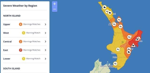
 No comments


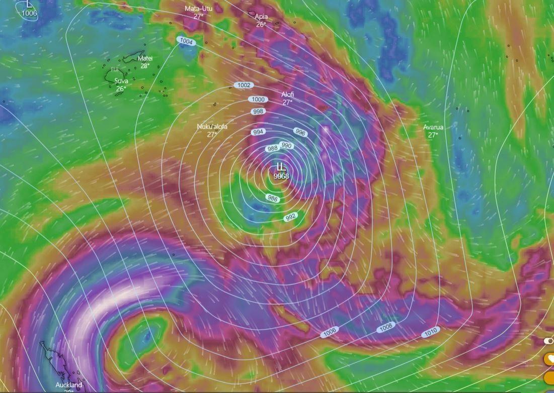


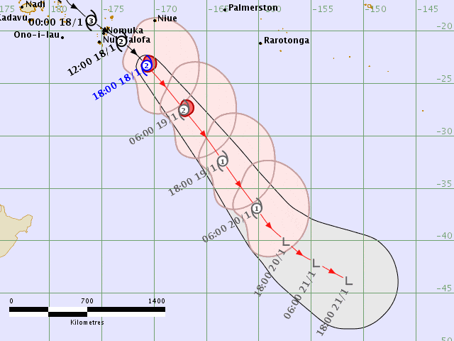


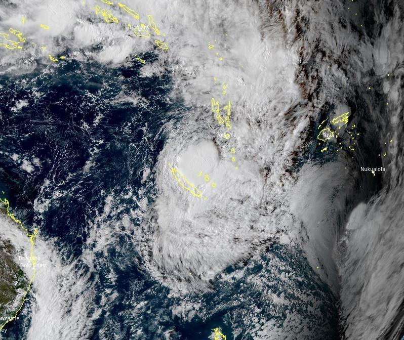
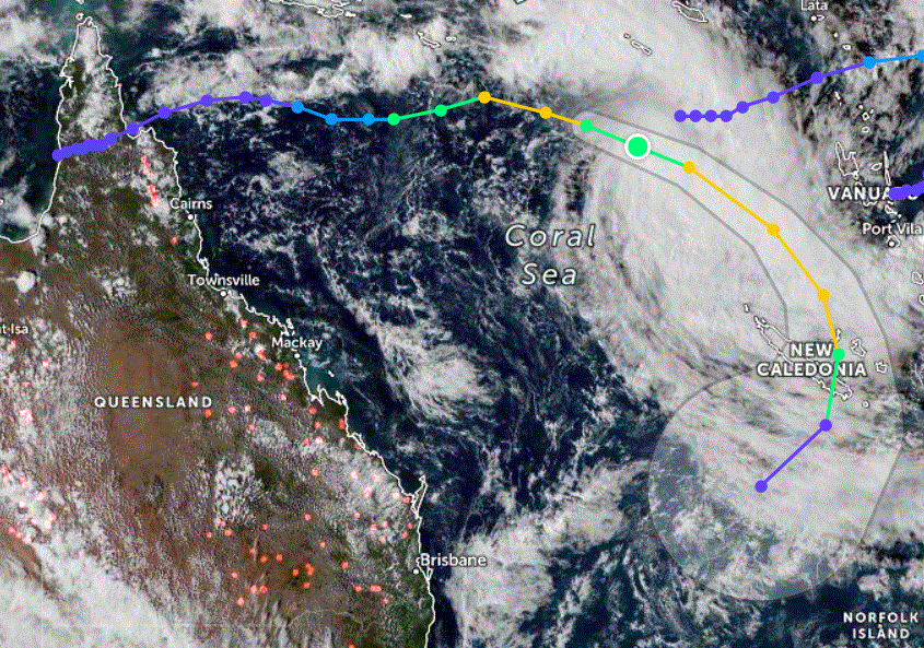
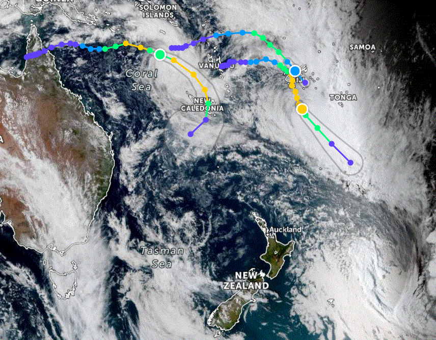


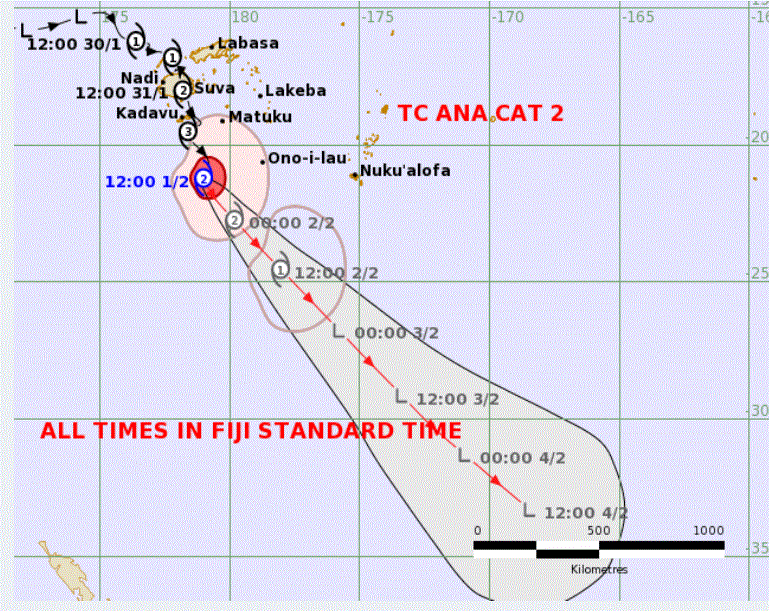
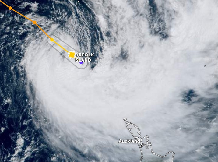
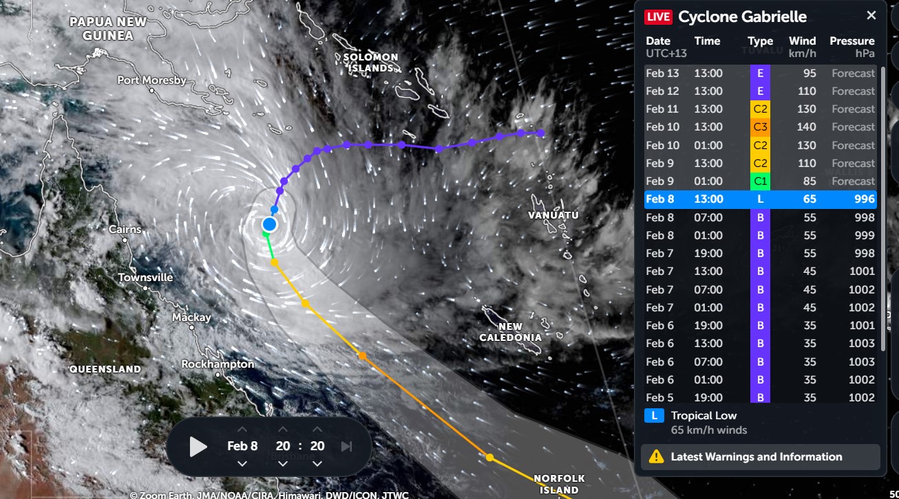
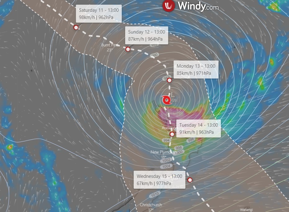
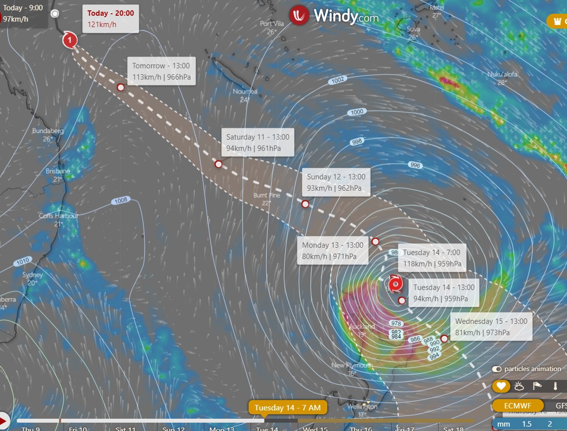
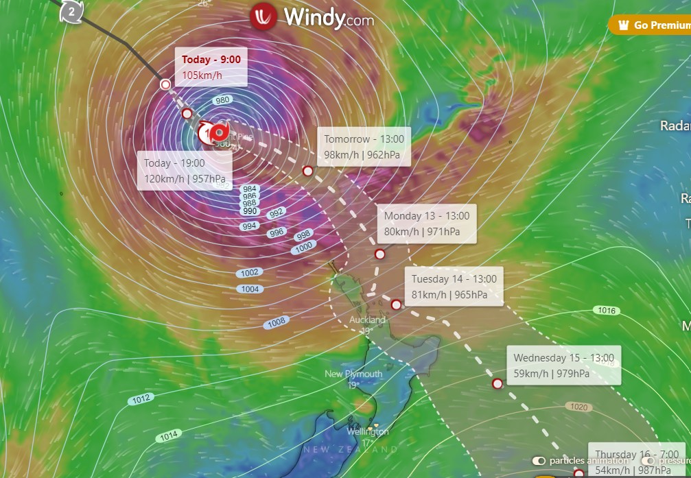
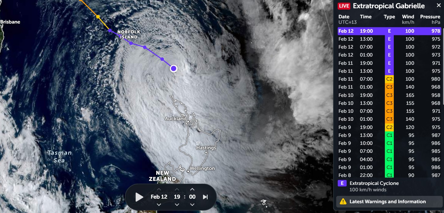
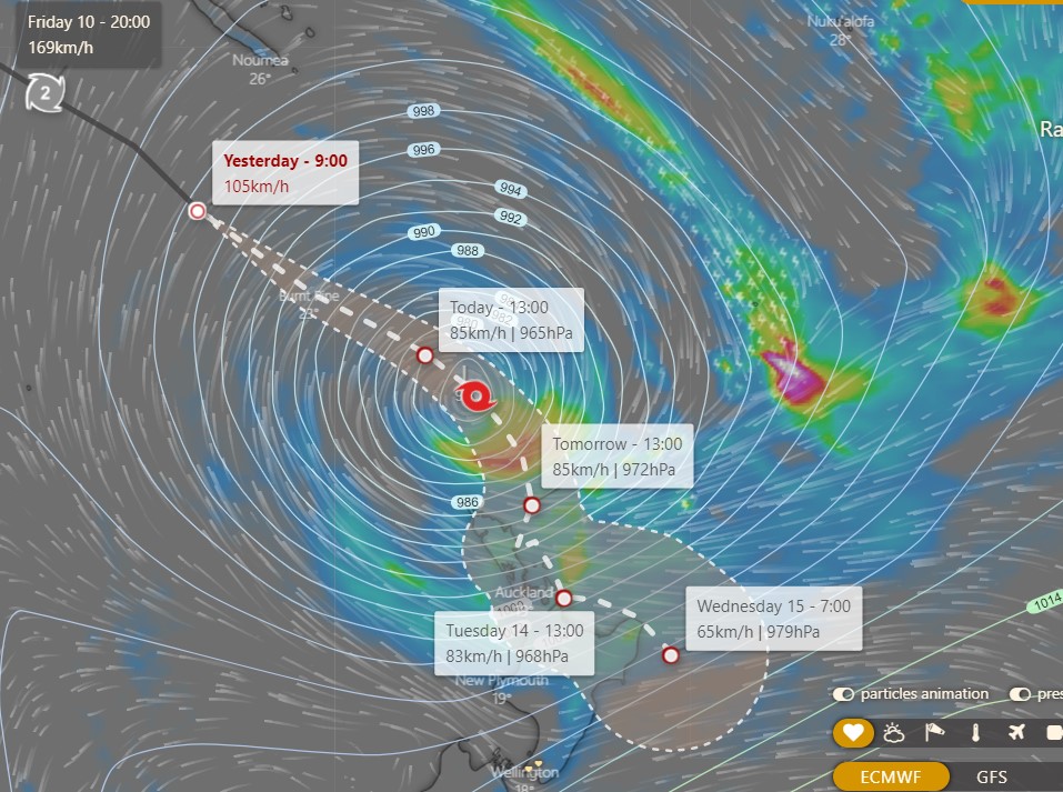
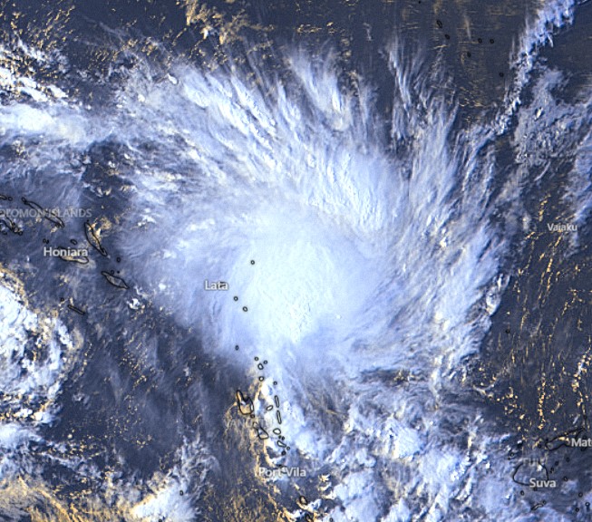
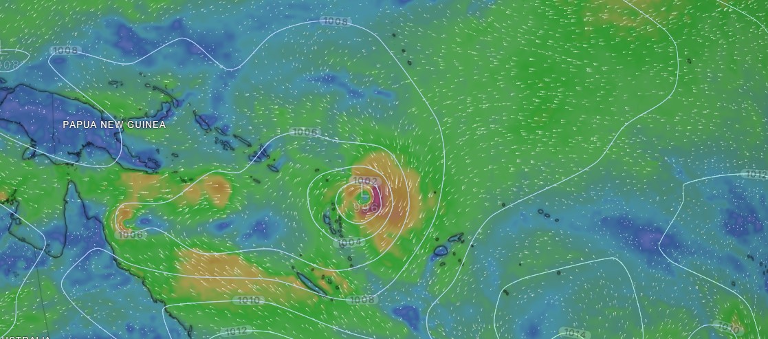
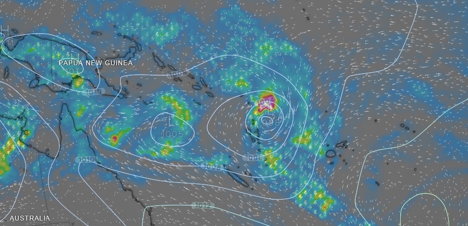

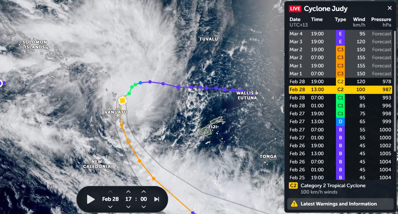
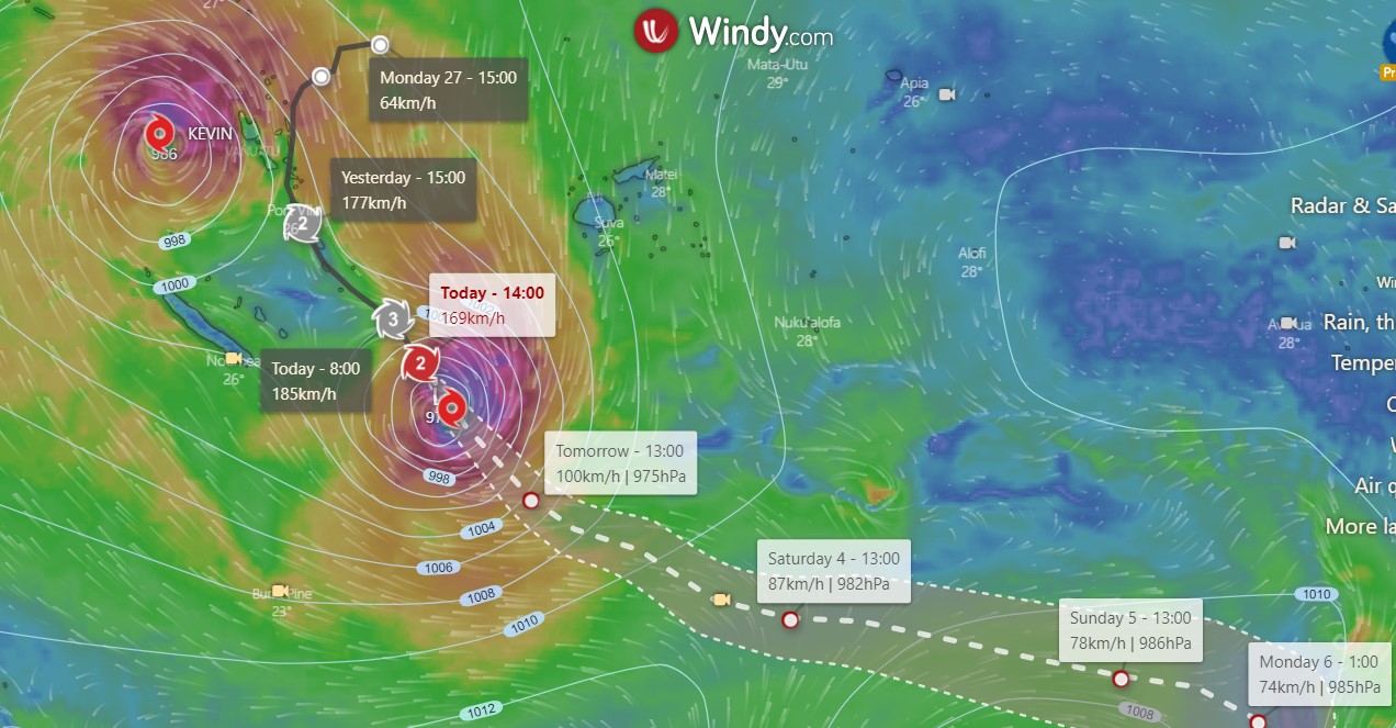
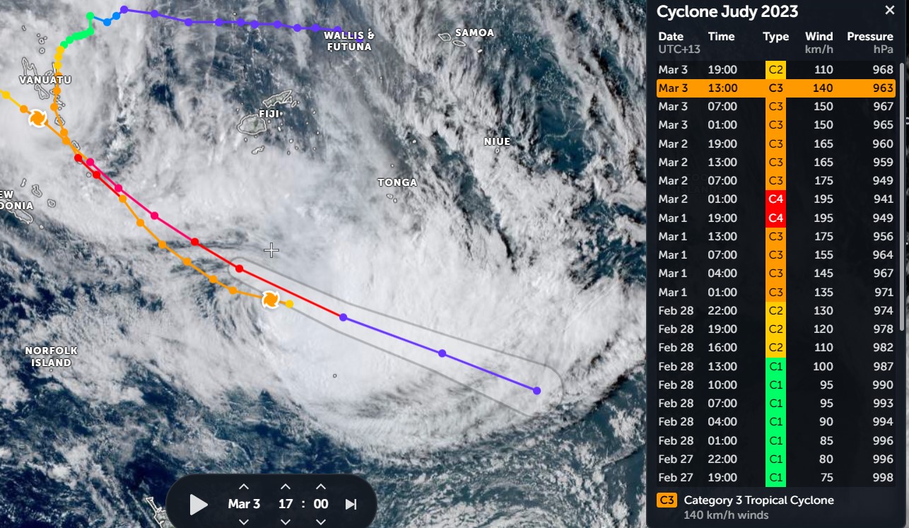
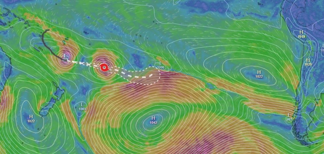
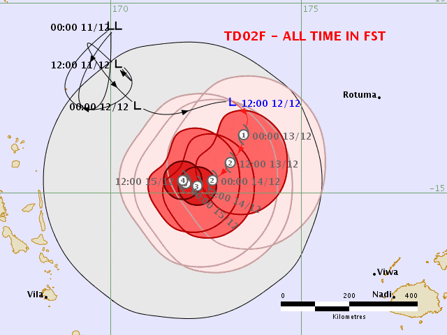
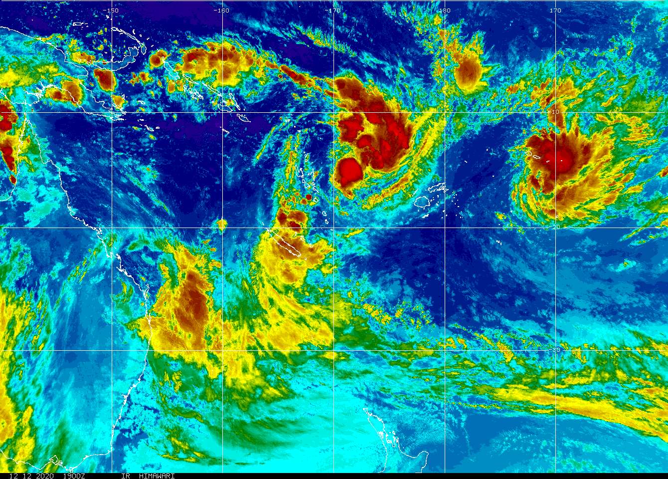
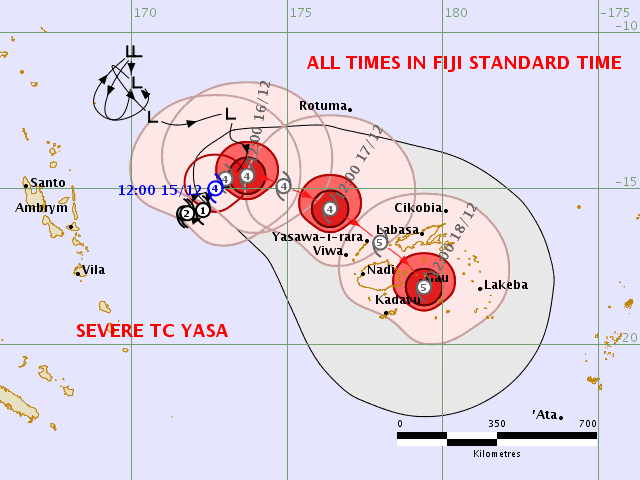
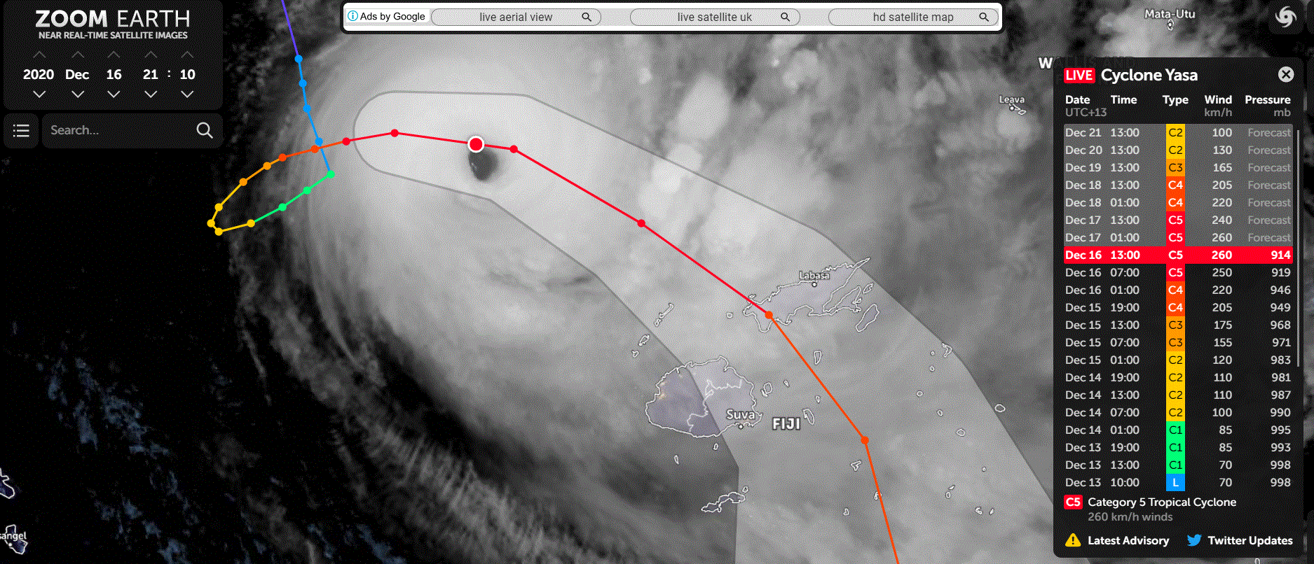
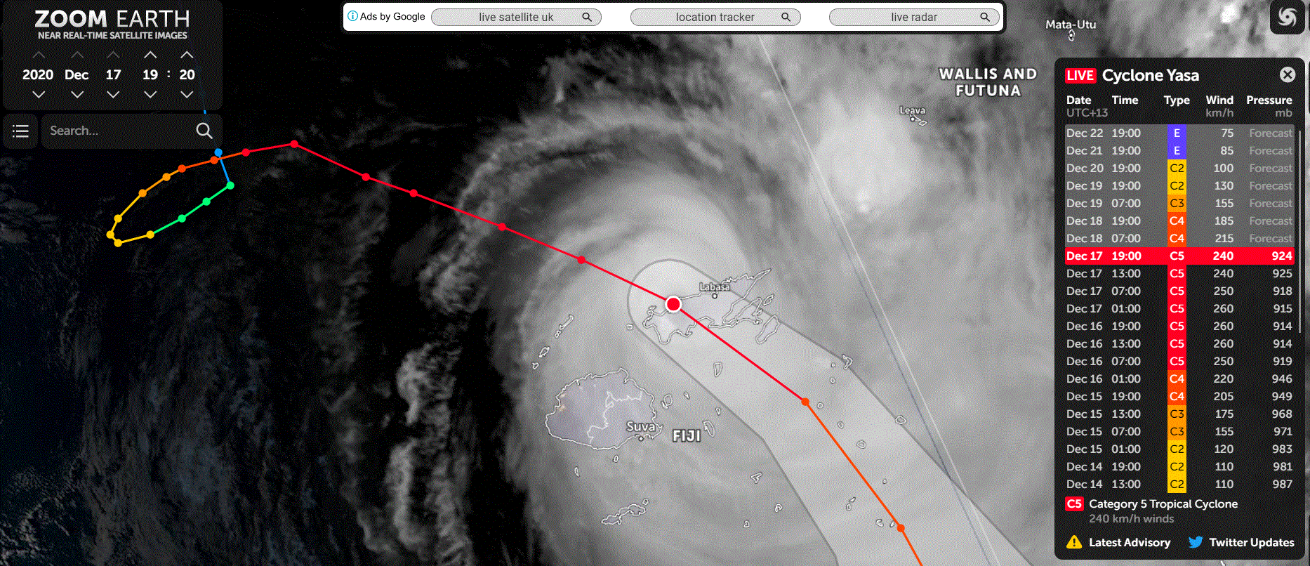
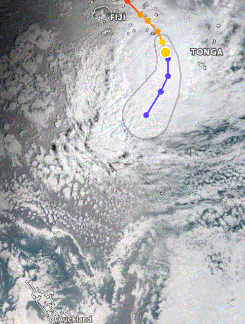
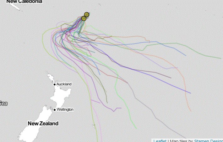
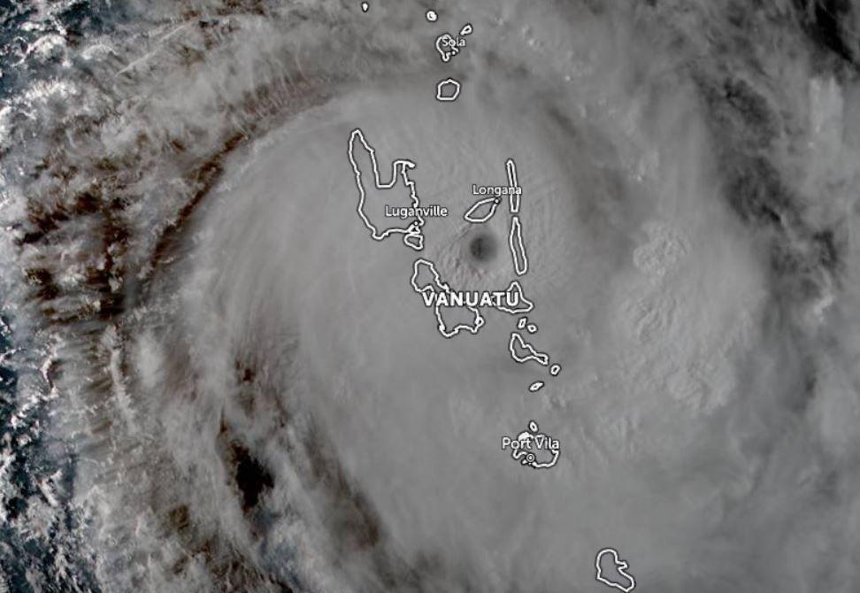


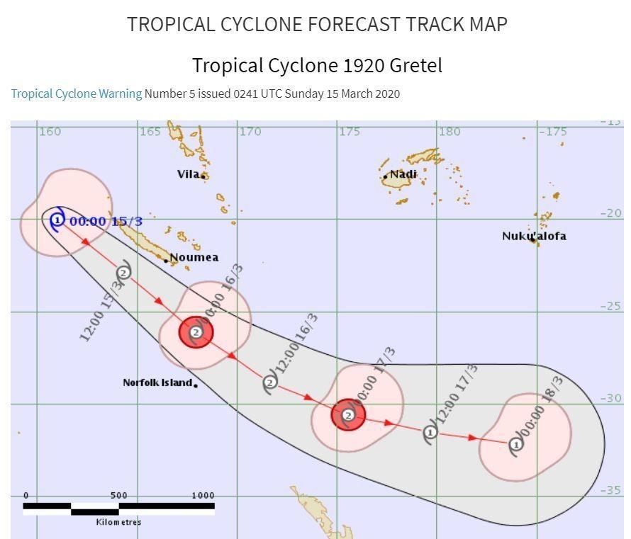
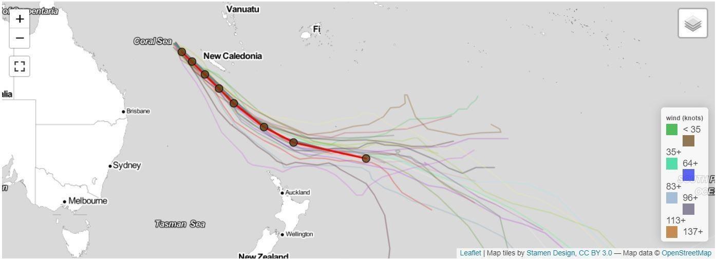
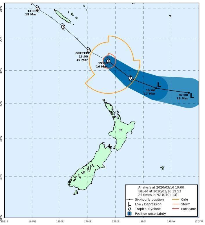
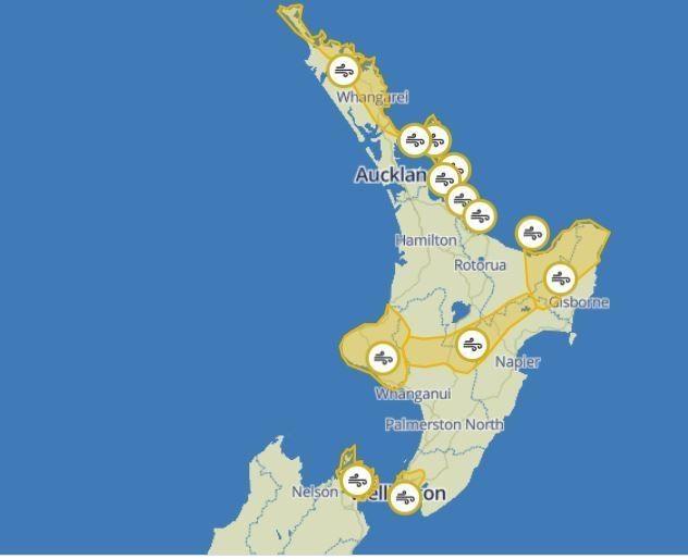
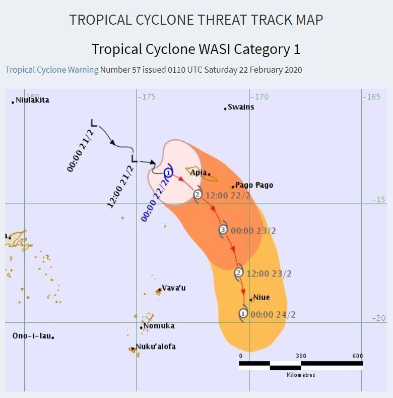
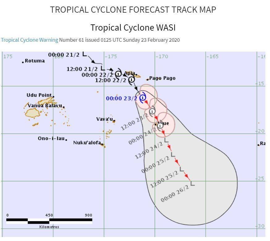
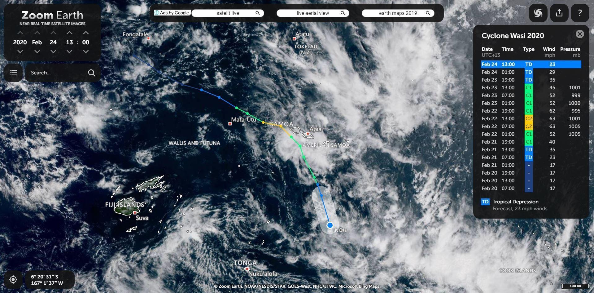
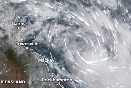
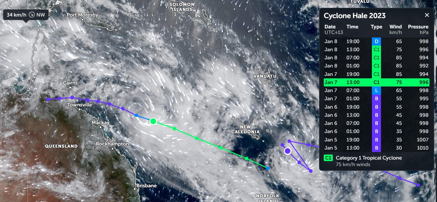
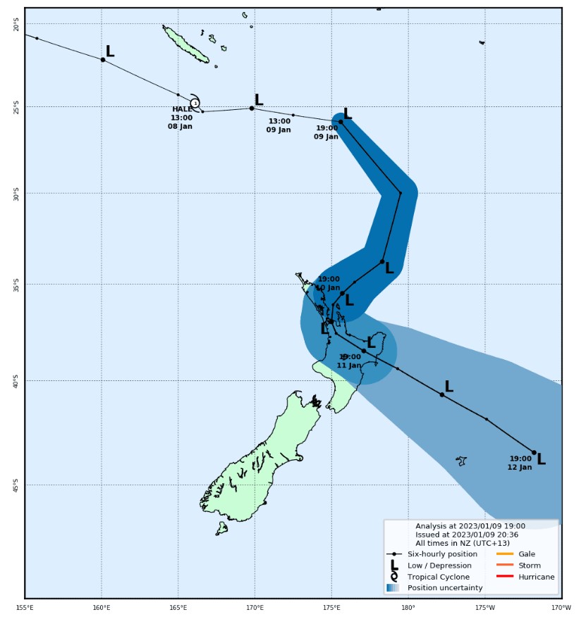
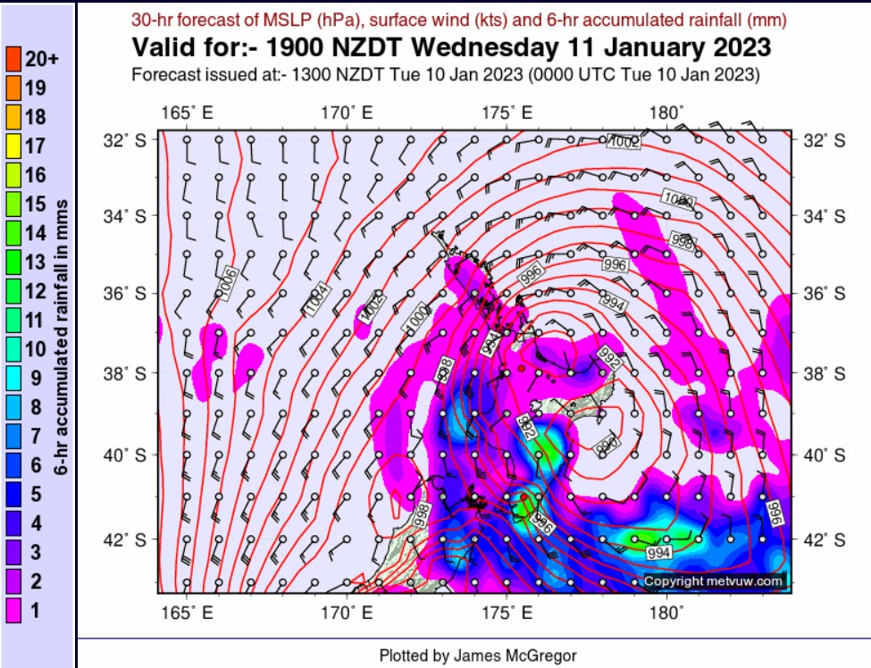
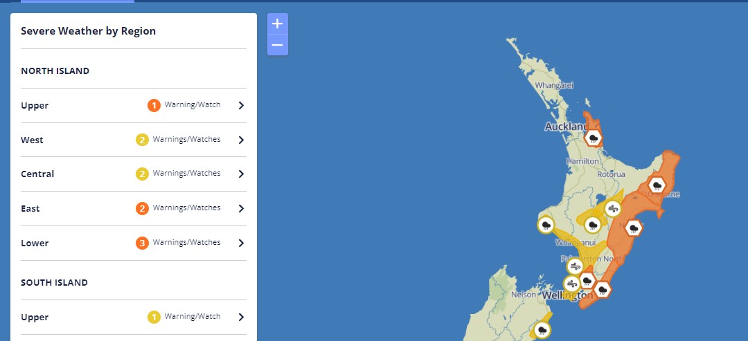
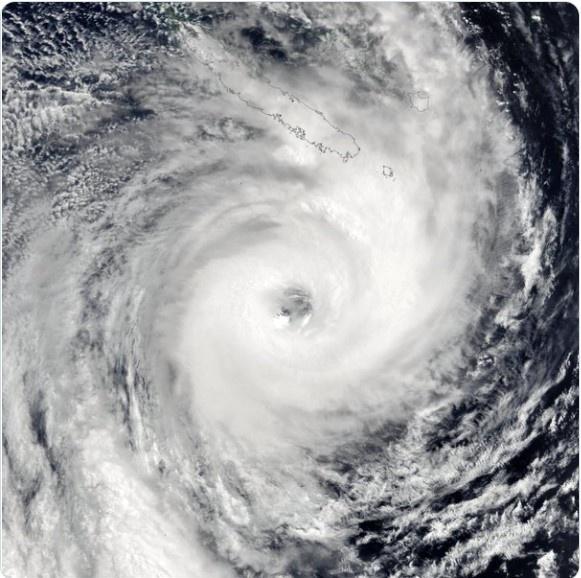


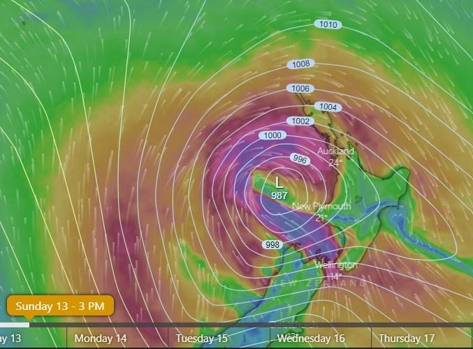

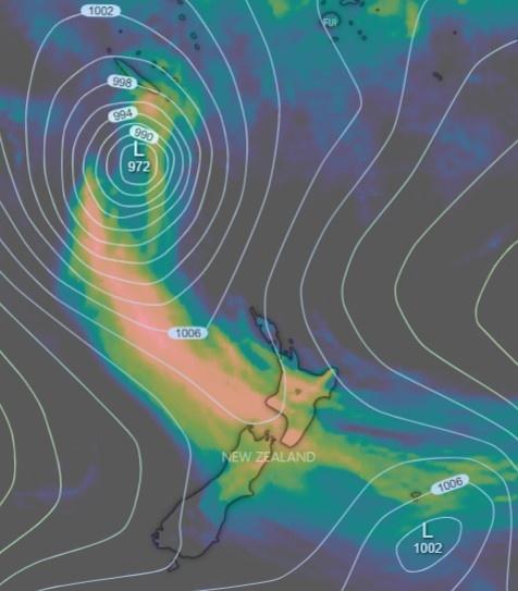


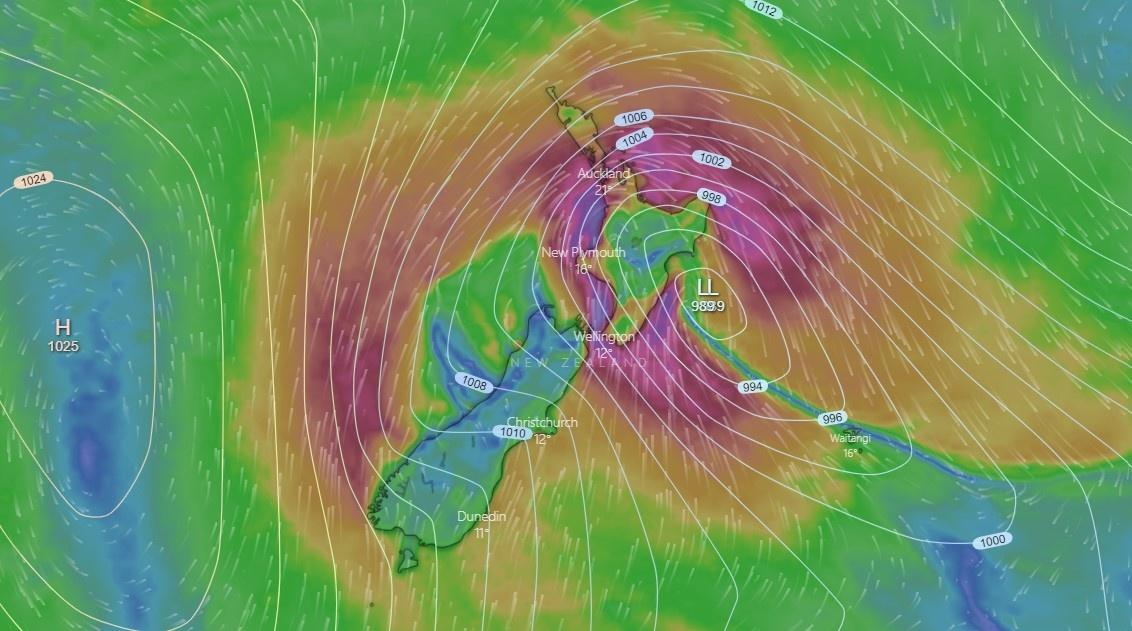
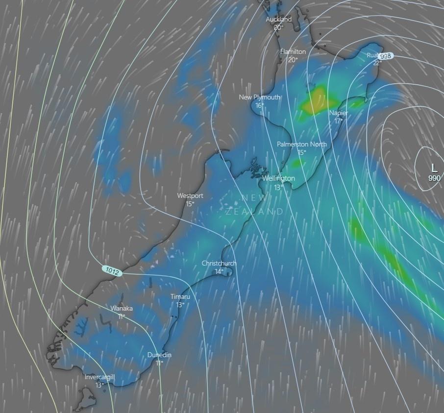
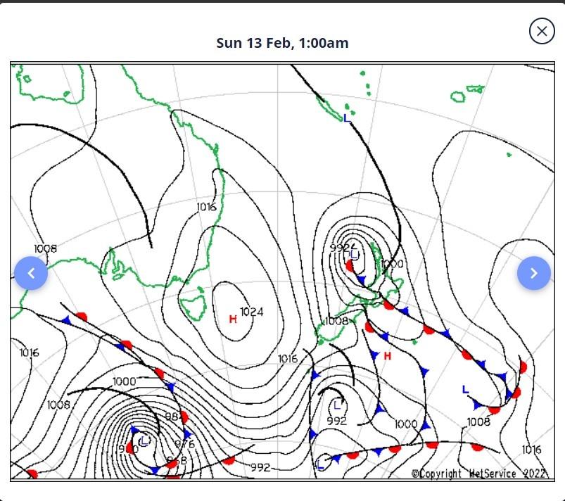
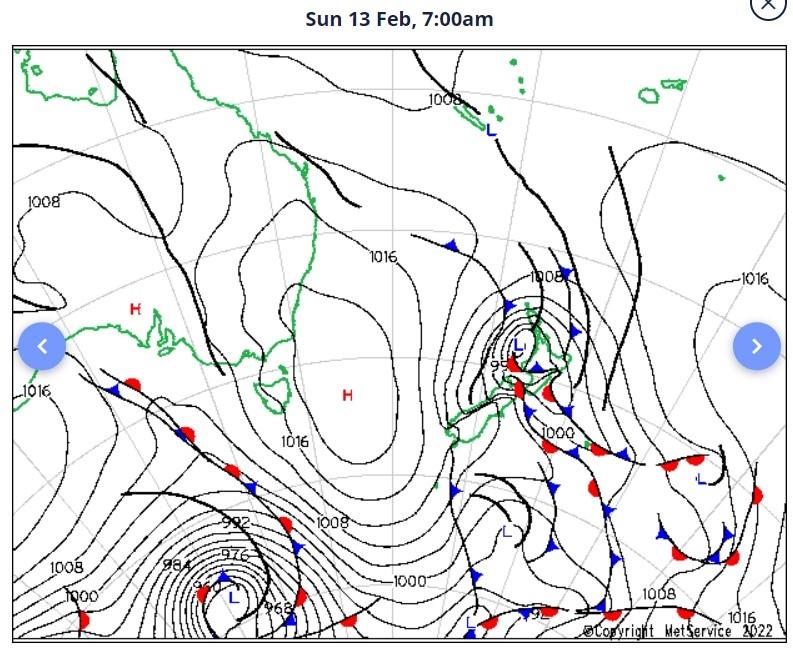
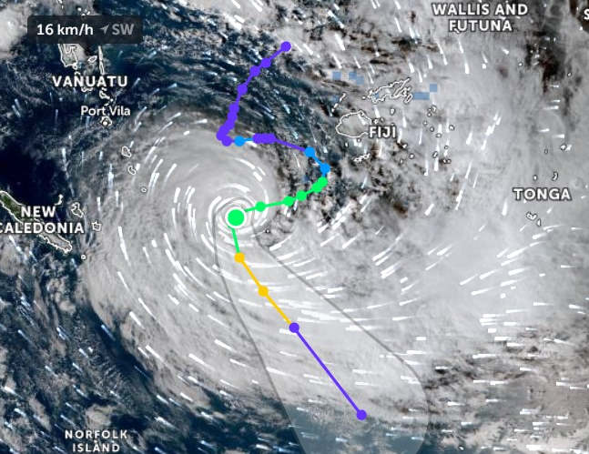
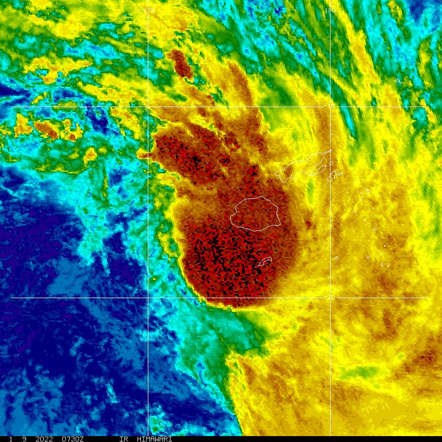 NZDT